
Opened 1977 | ||
 | ||
Similar Allatoona Dam, Great Smoky Mountains, Richard B Russell Dam, Millers Ferry Lock and Dam, Mossyrock Dam | ||
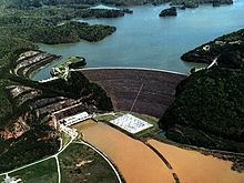
Carters Dam is an earthen embankment dam located south of Chatsworth in Murray County and west of Ellijay in the U.S. state of Georgia. The dam is 445 feet (136 m) tall and is situated 26.8 miles (43.1 km) above the mouth of the Coosawattee River. The drainage area is 376 square miles (970 km2).
Contents
Map of Carters Dam, Chatsworth, GA 30705, USA
It creates Carters Lake, the deepest lake in Georgia.
The dam took 15 years to build and was completed in 1977. The area of the primary flood control pool is 3,880 acres (1,570 ha). The top elevation of the dam is 1,112.3 feet (339.0 m). The top width of the dam is 40 feet (12 m).
The dam has a diversion tunnel that is 2,407 feet (734 m). It is a horseshoe shape with a bottom width of 2 feet (0.61 m) and a maximum height of 23 ft. The dam is constructed of rock and earth and is the tallest earthen dam east of Mississippi river. The lake is the deepest manmade reservoir east of Mississippi river. The created lake is more than 450 feet (140 m) deep and has 62 miles (100 km) of shoreline without any private docks or other development.
Hydroelectric plantEdit
Below the dam is a 1,000-acre (400 ha) retention and re-regulation lake. The hydroelectric plant is of the pumped storage type. That is, during off-peak hours the water from the retention lake is pumped back up into the lake for use in generating power during the next time of peak demand. The dam's power station contains 2 X 140 megawatts (190,000 hp) Francis turbines and 2 X 160 MW Modified Francis pump turbines for used in pumped-storage.