
Mancomunidad Manc. Beturia Area 226 km² Local time Sunday 9:14 PM | Municipality Cartaya Elevation 26 m Population 19,168 (2014) | |
 | ||
Weather 17°C, Wind NW at 11 km/h, 84% Humidity | ||
Cartaya is a Spanish locality and municipality in the Province of Huelva (autonomous community of Andalusia). In 2010 had 18,415 inhabitants. Its surface area is 226.4 km² and has a density of 81.34 people per km².
Contents
- Map of 21450 Cartaya Huelva Spain
- Toponymy
- Symbols
- Situation
- Orography
- Climatology
- Hydrology
- Ecology
- Prehistory
- Romanization
- Middle Ages
- Modern era
- Contemporany era
- 20th century and 21st century
- Population cores
- Demography
- Local Administration
- Economy
- References
Map of 21450 Cartaya, Huelva, Spain
Cartaya was founded as an urban core by the Marquis of Gibraleón, D. Pedro de Zúñiga in Piedras estuary, although its name comes from the Phoenician word "Carteia" meaning city so presumably its settlement, though not continuous, is older. Different traces found on its territory has been dated from the time of the Decline of the Roman Empire because it was an important communications hub between East and West. Is also documented the existence of population centers in farmsteads adjacents in the Middle Ages, which demonstrate that from ancient times lived in this area.
The municipality's economy is mainly based on the primary sector, although in recent years of the 20th century encouraged the service sector using their leisure opportunities found in coastal areas and their natural surroundings. The per capita income is high, considering the neighboring municipalities. The cores of El Rompido y Nuevo Portil along with the numerous developments emerged in recent decades has enabled also an important population growth.
From its term include the 4 km of beach (El Rompido, San Miguel Beach, Nuevo Portil beach and the westernmost part of El Portil, an atypical urban image due to the segregation of Punta Umbría), as well as, the former Convent of the Blessed Trinity, the Parish Church, the Hermitage of Santa María de Consolación and the Castle of the Zuñiga.
Toponymy
The toponym Cartaya seems to be of Phoenician origin: Qart or Carteia that might be translated as The City. It must not get confused, nevertheless, with Libertinorum Carteia in San Roque. In the Andalusian period appeared under the name qarqaya, phonetically very similar to the present.
Symbols
The municipal blazon is:
Of gules, golden castle of vert abjured sustained natural mount, and this sustained of silver and azure waves. On both sides of the castle, two mace-bearers.
It was approved by decree of 21 July 1972, and published in the BOE on 24 August that year.
The municipal flag was adopted in plenary municipal 10 August 1998 and it has the following description:
Red with six bands in the low, three white and three blue. Centered and superimposed local arms.
Situation
It is located at 26 km of Huelva and 112 km of Seville. It remains represented in the leaf of MTN50: n.º 999 (2001).
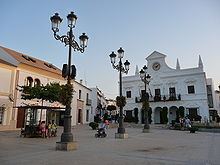
Cartaya's municipal area is located in the southwest of the province of Huelva in the coastal area and limited from east to south for the Piedras River and its river mouth, giving origin to the San Miguel beach. The urban core is situated on foot of the riverside of the Piedras while the cores of El Rompido and El Portil – latter also belongs to Punta Umbría – are located in the river mouth of the Piedras and on foot of the Atlantic respectively.
The municipality covers an area of 226.4 km² with an average altitude of 26 masl.
Cartaya's municipal area limit with: the most nearby locality, five miles, which it is Lepe, whose border is the river Piedras; also it limits, to the north-east with Gibraleón and to the south-east with Punta Umbría, locality that it segregated of Cartaya in the 1960s.
Orography
The urban core is nearby to the right of the bank of the river Piedras, riverbed at whose river mouth is placed the village of El Rompido. Radically is the most interior zone of pinegroves and small elevations that make it more abrupt. Therefore, the relief of the zone can be summarized in the existence of three geographic units that would correspond to the fluvial-coastal zone formed in the Quaternary Period to the San Miguel Beach, to the zone of field and to the zone of coppice.
The soil is composed by gravels and conglomerates of detritic coverages, glacis and erosion of hillsides. In the mountainous zones show outcrops of Paleozoic shales.
The most important space is the known as Arrow of Nueva Umbría, whose territoriality, due to its relatively recent formation, is a motive of polemic between Lepe and Cartaya. Also it is important the space of the Lagoon of El Portil (in terms of Punta Umbría).
Climatology
The climate is continentalized Mediterranean obviously mediatized by its nearness to the sea. The winters are very mild, temperatures rarely become negative and rarely drop below 10 °C, on the contrary the summers are very warm middle registering in July and August over 33 °C. The annual average is around of 18 °C. The precipitations are not usually very abundant.
Later, it shows the average of temperatures and rainfalls throughout the year 2007:
Hydrology
Its principal fluvial course is the river Piedras, which constitutes the oriental limit of its term and delimits it with the municipality of Lepe. It is born in the municipal area of El Almendro, though most of the creeks that give origin and come from the highlands of El Almendro, are born in Villanueva de los Castillejos's municipal area. Originally it flowed into the village of El Rompido, toponym that originated because it was in that zone where the waves were breaking against the river sediment. These sediments deposited in an easterly direction, it made possible great mobility in the ria Piedras, quickly developing many places like the Lagoon of El Portil when it is closed.
Chanza Reservoir, in another municipality, provides water to the locality.
Ecology
It exist a large forest mass composed by extensive pinegroves (about 12,000 hectares), junipers, new plantations of eucalyptus trees and some zones, very small, of evergreen oaks and corks. All this, along to the so-called Natural Place Marshes of the River Piedras and Arrow of El Rompido, compose an extensive land in relative semi-virgin condition. It is a question of the only formation in the Andalusian littoral. Its formation is due to the wind and marine huge deposits of the Río Piedras, of the flow of tides and of the waves.
The Arrow of El Rompido receives three main ecosystems (dune, retama, and marsh) with very little vegetation as sea holly, beachgrass, white retama, mastic and diverse halophytic vegetation.
Prehistory
There are few prehistoric archaeological evidence in the area. Around the river mouth of the Piedras, it has been found small pieces of Lower Paleolithic stone tool, as early acheuleans deposits (edges and some bifaces and beaks) or Mousterian type of Middle Paleolithic. There isn't any connection between the populations of the shores of the Piedras, the Odiel and the Tinto. The first historical evidence of population current in Cartaya's urban core aren't date back to Phoenician times.
Romanization
If Cartaya's core and its nearby coast (where there are many discoveries of shipwrecks) weren't probably inhabited until the Phoenician arrival, it will not be until century later, when it proceeds a significant advance. In Roman times it was located in regions named as Beturia Celtic and Turdula, inside the Senatorial Roman province of the Baetica. Cartaya was located near to the distance of the road that was joining the cities of Praesidio and Ad Rubras and for zone it might arrange in the certain zone pottery industry, especially amphorae, before the demand of the settlement of Punta Umbría or Onuba Aesturia.
As is common throughout the zone of Huelva, the Visigothic presence in the region was very slightly significant.
Middle Ages
During of times of Al-Andalus, under the name of Cashtm these lands remained nailed in Cora of Labla, a Cora belonging to Għarb al-Andalus. After the fall of the Caliphate of Córdoba in 1012, it joined into the Taifa of Huelva until it also disappeared and it joined into the Taifa of Seville in 1052.
After the Christian conquest of the north of Huelva, in the 13th century, after the capture by Alfonso X the Wise in 1262 of the cities of Niebla and Huelva, the current province of Huelva received importance as frontier territory with Portugal, serving as break to the expansionist politic of this country and denominated Banda Gallega to great part of that border. It will be already in 1269 when the border with Lepe is formed across the Piedras:
Otrosí mandamos a Maestre Fernán García [...] que partiesen los términos entre Gibraleón e Ayamonte e ellos partieronlos e pisieron los moxones de esta guisa. Como caye el río de las Piedras en la Mar e va derechamente arriba e sacude a la Alcaria de Mertola e de esta Alcaria a Moxon cubierto hasta Guadiana.
Modern era
During the 15th and 16th centuries, Cartaya became part of the dominions of the Zuñiga's House. The area was unsafe because it was frequently attacked by Berbers and Normans pirates. Until Marquess of Gibraleón, Pedro de Zuñiga and Manrique de Lara, didn't win a lawsuit with Alfonso de Guzmán, M. of Ayamonte and Lepe, for which a step could established by boat across the river Piedras and found next to him the population to be able to defend such a step, there was no certain normality in the zone. Seven years later, he gave the orders to initiate the works of the castle, located today to the west of the current urban area and of that only the court of weapon remains. The construction of the fortress, ideal refuge for the population, ends for consolidating the current settlement. Also on that date, the first church was built in Mudéjar style, on which subsequently got up the present Parish of San Pedro. His descendant, Álvaro of Zúñiga consolidated the familiar power in the Lower Andalusia and his eldest son, on having married the daughter of Juan Alfonso of Guzman III was done finally in dowry of Ayamonte, the nearby Lepe and La Redondela.
Mention separate the Port of La Ribera deserves. This one enjoyed already in 1509 of an undoubted traffic, having trade with the Port of Seville (fishing in him a ship from Cartaya) or with Flanders. The ships from Cartaya were fishing in Cape Spartel and Cape Bojador and there existed cabotage transport, wine trade and grain. Also, it was having shipyards receiving documents the manufacture of caravels in the 15th century. While, the port of Castle of San Miguel Arca de Buey, at the river mouth of Piedras began to remain isolated. In spite of it, Cartaya didn't have importance that more or less nearby populations like Palos de la Frontera or Moguer had in to develop historically into the navigation. Nonetheless, local sailors were participants so much in the first voyage of Columbus, where names appear as Talafar, Vizcaino and Alonso Rodríguez, as whom in the Second Columbian expedition, where they went also in the caravel La Niña, the sailor Rodrigo Calafar from Cartaya, in the caravel San Juan, Alonso Rodríguez and in the caravel Cardera, Juan Vizcaíno.
The still insecure population moved to Trinitarians of Barefoot Mercy, order dedicated to the redemption of captives, to settle in the locality as it had in other nearby locations. Nonetheless, the settlements continue to be unstable disappearing ancient medieval villages such as San Miguel de Arca de Buey and population decrease in the core as consequence of a plague epidemic in 1602. This critical stage contrasts with that of later centuries, especially when in the 18th century, there develops great part of Cartaya's current urban plot in spite of the presumable destructions (as in the conventual building) of the 1755 Lisbon earthquake.
Contemporany era
During the years 1804 to 1808, it belonged to the Sanlúcar de Barrameda's maritime Province and the kingdom of Seville up to the new administrative division of 1833, it ended being included in the new province of Huelva.
In the last third of the century, the village of El Rompido arises. Though previously, other small settlements had existed in the river mouth of the Piedras, during these years it began to work an almadraba on "the other side" of river. As terrestrial communications with Cartaya had to be made from the left bank of the river, families were settled in the current core. These families were usually formed by men of foreign origin, many of them were coming from the neighboring Portugal, with women from Cartaya. Portuguese surnames as Almeida or Brito are still common in the zone.
20th century and 21st century
In 1963, there was segregation of the core of Punta Umbría. In the face of the demands of this due to its remoteness to the core and its tourism and economic growth, the City Council had launched a dossier requesting to the Council of Ministers the revocation of the Decree of 15 January 1959 that its segregation of the core was accorded counterfoil. Finally, the negotiations were unsuccessful and Punta Umbría became a new locality of the province with border scarcely to eight kilometres from El Rompido 26 April 1963. Thereafter, it proposed El Portil as space for its tourist dynamization. In 1968, it approved a revitalization plan that it resulted unsuccessful propitiated scarcely a slight development of the zone.
With the arrival of democracy and the promulgation of the Spanish Constitution of 1978, Cartaya, as whole the state, obtained new competitions and it experimented an important development placing between one of the localities most populated in the province of Huelva at present.
Population cores
Composed by Cartaya's provincial core, the village of El Rompido (and its bordering urbanizations of Urberosa and Los Pinos) and the urbanization of Nuevo Portil. In addition,it exist a great number of buildings in spread.
Demography
The population is of 18,415 people in 2010, composed by 9,508 men and 8,907 women. The growth in recent years has been significant, doubling the actual population that existed at the end of the 1980s. In the 1960s, it decreased significantly the census because, in 1963, it became free the village of Punta Umbría from Cartaya.
The analysis of the population pyramid shows the following:
This population structure is typical in modern demographic regime, with an evolution towards an aging population and a decrease of the annual birth rate.
The foreign population registered in 2009 adds 3,197 inhabitants, that it represents a percentage of 17% of census, very superior to the national and regional average, being the most numerous nationalities the Moroccan (876 inhabitants), the Romanians (1003) and the Ecuadorian (120).
Local Administration
The political administration of the municipality is realized through a City Council democratically management whose members are elected every four years by universal suffrage. The electoral census is composed by all the residents registered in Cartaya over 18 years and natives of Spain and of other countries members of the European Union.
According to the Law of the General Electoral Regime, which establishes the number of councilors elected on the basis of the population of the municipality, Cartaya's Municipal Corporation is composed of 17 councilors. In the last Municipal Elections celebrated in 2007, Juan Antonio Millán Jaldón was re-elected mayor, being the constitution of the City Council the following one:
Economy
In 2008, there were in the municipality, a total of 1,105 companies, of which 990 had a workforce of less than 5 workers, 91 companies had a workforce between 6 and 19 workers and, only, 24 companies had a staff of more than 20 workers. With the current economic crisis that is occurring in Spain, it is possible that the data corresponding to the present (2010) are considerably lower than that digits because there are many companies which are ceasing their activities.
Cartaya also belongs to the Mancomunidad of Municipalities Beturia for what this one as the region in which integration takes place several initiatives to promote economic development. One of these was the creation of the School of Business of Cartaya (ULOPA) that is responsible for local economic dynamization.