
Traversed by SR 88 Reference no. 315 | Elevation 2,637 m | |
 | ||
Similar Sierra Nevada, Ebbetts Pass, Sonora Pass, Echo Summit, Red Lake Peak | ||
Carson Pass is a mountain pass on the crest of the central Sierra Nevada, in the El Dorado National Forest and Alpine County, eastern California.
Contents
- Map of Carson Pass California USA
- Hike to winnemucca lake carson pass hope valley california usa
- HistoryEdit
- Maidens GraveEdit
- References
Map of Carson Pass, California, USA
The pass is traversed by California State Route 88. It lies on the Great Basin Divide, with the West Fork Carson River on the east and the South Fork American River on the west.
The historic pass was a point on the Carson Trail during the California Gold Rush and was used for American Civil War shipping to California until the completion of the First Transcontinental Railroad. The Pacific Crest Trail traverses the Carson Pass summit, which has California Historical Landmark #315 at CA 88 postmile 6.09 where Kit Carson carved his name into a tree.
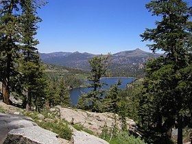
Hike to winnemucca lake carson pass hope valley california usa
HistoryEdit
The 1844 Frémont Expedition turned south from northern Nevada. When encamped at Nevada's Carson Valley on January 31, 1844; guide Kit Carson suggested the expedition detour west during the winter conditions to Sutter's Fort in California for supplies. Local Washoe Indians told them of a route through the mountains, but warned them not to proceed through the snow. Frémont duly ignored the advice and directed the group westward. The Washoe were right in that they would not be able to find food or game, and they ended up resorting to eating dog, horse, and mule just to survive. On February 14, Frémont and his cartographer Charles Preuss made it up Red Lake Peak and became the first recorded white men to see Lake Tahoe in the distance. On February 21, the expedition made it through the now-named Carson pass west of Red Lake and arrived at Sutter's Fort on March 6 with no fatalities.
In the summer of 1848, Mormons leaving California for Utah built what would become known as the Carson Trail across the Sierra from Sly Park, California to the Carson Valley via Carson Pass. The Carson Trail became one of the primary routes across the Sierra used by overland immigrants to California in the Gold Rush era. Brigham Young evacuated Mormon settlers around Carson Pass in July 1857, shortly after the breakout of the Utah War.
Maiden's GraveEdit
In 1850, Rachel Melton was buried west of Carson's Pass. Her family was traveling from Iowa when Rachel, a young girl, became ill. The family camped out with a goal to improve on Melton's health, but she died. The site is a California Historical Landmark.