
Topo map IGM, CT-ÑIV-C1 [1] Last eruption Unknown First ascent 1951 | Mountain type Caldera Elevation 5,018 m Prominence 620 m | |
 | ||
Easiest route glacier/snow/rock climb AD Similar El Altar, Illiniza, Chimborazo, Sangay, Antisana | ||
Mount Carihuairazo (also Carihuayrazo) is a volcanic caldera neighboured by Ecuador's highest mountain Chimborazo.
Contents
- Map of Volcano Carihuairazo Ecuador
- LocationEdit
- GlacierEdit
- VolcanismEdit
- EtymologyEdit
- First AscentEdit
- ClimbingEdit
- RoutesEdit
- References
Map of Volcano Carihuairazo, Ecuador
LocationEdit
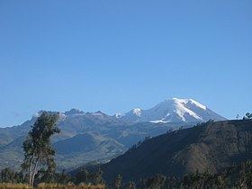
Carihuairazo is located in the Cordillera Occidental of the Andes of central Ecuador, 150 km (93 mi) south-southwest of the capital Quito. Its neighboured by 6,310 m high Chimborazo. The nearest cities are Riobamba (~30 km to the southeast), Ambato (~30 km to the northeast) and Guaranda (~30 km to the southwest). Carihuairazo's 1.5 km wide heavy eroded caldera opens to the east.
The Carihuairazo forms part of the "Reserva de Produccion Faunistica Chimborazo" which forms a protected ecosystem to preserve the habitat for the andens native camelids Vicuña, Llama and Alpaca.
GlacierEdit
Carihuairazo's Glacier lost almost all of its mass during the last decade as a result of global warming and ash covers caused by the recent volcanic activity of its eastern neighbour Tungurahua. At current rate Carihuairazo's Glacier is expected to completely disappear between 2020 and 2030.
VolcanismEdit
Carihuairazo must have been a Volcano of similar dimensions to its neighbour Chimborazo before explosions during the last period of activity destroyed the mass of the peak, leaving today's caldera. There is no evidence of historic activity and Carihuayrazo is considered inactive.
EtymologyEdit
An interpretation of its name is that it's a combination of the Quichua words Cari (man), huay (wind) and razu (Ice/Snow) (Schmudlach 2001). Local Indian mythology narrates that Carihuairazo and El Altar which are both volcanic calderas have been destroyed by Taita (Father) Chimborazo fighting for the grace of Mamá Tungurahua.
First AscentEdit
Carihuayrazo was climbed by Edward Whymper and the brothers Louis and Jean-Antoine Carrel during their 1880 Ecuador expedition. It is not entirely clear out of Whymper's descriptions but it is believed that they climbed the Mocha (4,960m) and not the Maxima summit (5,018m). The first ascent to the Maxima summit is attributed to Arturo Eichler, Horacio Lopez Uribe and Jean Morawiecki in 1951 (Neate 1994).
ClimbingEdit
Due to the glacier retreat and its consequences climbing Carihuairazo has shifted from a PD glacier route with some rock scrambling to an AD route with a technical climb to the summit tower (Maxima, 5,018m).
RoutesEdit
The normal route to Carihuairazo Maxima (5,018m) starts from a camping spot at ~4,600m, reaching the main ridge either via the SW-ridge or from West via the glacier, followed by a difficult technical climb to reach the summit tower.