
 | ||
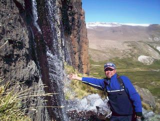
Carhuasanta is a small river located in the Arequipa Region of Peru. It is known as the headwaters of the Amazon River. The brook is fed by the winter snows of Nevado Mismi, (5,597 m), some 6,400 kilometers from the Atlantic Ocean. Of all the possible river sources in the Amazon Basin, it is the snow melt of the Carhuasanta that has been calculated by cartographers to be the furthermost water source from the mouth of the Amazon.
Contents
- Map of Carhuasanta Fuente del Amazonas Peru
- National Geographic expedition
- Pre 1971
- 1982
- 1985
- 1987
- References
Map of Carhuasanta (Fuente del Amazonas), Peru
The Carhuasanta joins with the Quebrada Apacheta, becoming the Rio Lloqueta. The river has several more name changes before it becomes the Apurímac River. The mining town of Caylloma lies near the junction of four rivers that form the Apurímac river.
National Geographic expedition
The National Geographic Society sent a three-man expedition to the region in 1971, headed by Loren McIntyre. The expedition travelled from Caylloma by four-wheel drive, but soon got bogged. Continuing on by backpacking up the river, they climbed up the Apacheta Trail and traversed onto the mountain Mismi, taking in the mountains Kiwicha and Pumachiri. This is, as McIntyre describes it in his 1972 National Geographic article, "a semicircle rampart of the continental divide. All that trickles from the inner rim joins to form the Apurimac."
On 15 October 1971, we reached an ice-edged ridge above Carhuasanta, longest of the five headwater brooks. The Indians call that 18,200 foot summit Choquecorao ... A thousand feet below the ridge we sighted a lake... We clambered down to quench our thirsts... Here at 17,220 ft/5,249m was the farthest source of the mighty Amazon - more a pond than a lake, just a hundred feet across.
Mismi makes an unreliable source of water in the dry season. Laguna McIntyre, as the lake was called, is deemed the 'true source', as it is permanent. However, it is known that the source will change over time, perhaps in a single season, due to the changes of the weather and its impact on the microclimate. In the wet season the mountains and undulating altiplano are covered in snow. In the dry season it resembles a desert as the mountains crumble slowly to dust. The effect of global warming will no doubt accelerate the changing of the Amazon's source water.
Pre-1971
Very few people have visited the headwaters of the Carhuasanta. A walking track called the Apacheta Trail, used by locals, runs across the continental divide 13 kilometers to the west of Mismi, linking the villages of the Colca Canyon to the isolated valleys of the altiplano used by alpaca herders and their families, and to the mining town of Caylloma, 60 km distant (which can be accessed by a road from another direction). The locals have no interest in traversing the higher mountains of the divide.
Mismi was frequented by the Incas. "A gold figurine was discovered in a pirqa (Quechua for "wall", here a burial pit) on the summit by a South African father and son who were working in the Colca Canyon in the early 1970s." They didn't seem to know of the significance of the mountain as the source of the mighty Amazon, nor of the interest invested in it by others in the decades before.
1982
The third team to reach the top of the Mismi, in search of the 'true source', was Jean-Michel Cousteau and his crew in 1982. McIntyre writes, "Despite support by a helicopter and a monstrous six-wheel truck carrying five tons of equipment, Jean-Michel and his puffing lowlanders barely made it to the top."
1985
In 1985 a five-man team from the Los Angeles Adventurers Club, led by the late Emil Barajak, erected a heavy iron cross at the source.
In the same year, a 9-member international team organized by South African Dr. Francois J. Odendaal climbed out of the Colca valley and hiked up the Apacheta Trail with grandiose and expensive plans to run the Amazon by raft and kayak all the way to the sea. The team was torn with dissension - not to say mutiny. Odendaal, a South African, pulled out after they reached flat water at Atalaya with 3600 miles/5,794 km yet to go. Only Polish Piotr Chmielinski and American Joe Kane completed the journey to the Atlantic with Kane documenting it in the classic book Running the Amazon (1989). Kane documents in his book that he hiked for an hour to the top of a mountain, off the Apacheta Trail, and "touched the source" (a frozen river of water).
1987
One of the most unusual stories of reaching the head of the Carhuasanta comes from (South African-born) Australian adventurer Gary Caganoff. In 1987, guided only by an October 1972 National Geographic Magazine found in a Lima book market and a couple of topographic maps of the area, he walked alone, without support, 40 kilometers along the continental divide. It was an original route, perhaps unique in its undertaking.
Finding this route was an accident - it came about as a matter of survival. Caganoff had meant to begin his walk in Caylloma and follow the river up from there, just like McIntyre's party. However, in the truck he had hitched a ride on, he was warned by the drivers that if the terrorists stop them, being a foreigner, he would most probably be killed. Oblivious to Caganoff until then, he had travelled right into the heartland of the Shining Path. Quickly changing his plan, he was dropped on the road in the middle of the night, in the middle of the vast altiplano, with little food (as he was going to buy supplies in Caylloma). The only way out of this now sticky situation was to reach the source via the continental divide, then walk down into the towns of the Colca Canyon beyond.
Under a full moon he recognised the mountain Chunkara (5,286m) 5 km to his south which helped to orient him. In four days he crossed the lower western ridges of Chunkara, crossed the flat boulderous summit of the mountain Tiklla (Ticcla) (5,072 m), crossed the little rivers Kunturi (Condori) and Aquenta, and climbed the ridge up onto Aqu Kulluna (5,255 m), the north eastern ridge of the Mismi massif. Halfway along this ridge to the summit of Mismi, he spent an agonising night thinking he was dying of altitude sickness. He had had little food over the four days, which had made him weak. He bivvied next to a small snow drift on the north side of the ridge, overlooking the headwaters of the Carhuasanta.
His experience there is described in his website.