
Etymology Vincent of Saragossa Region Algarve District Faro District | Subregion Algarve | |
 | ||
Similar Lighthouse of Cabo de São Vice, Sagres Fortress, Praia da Rocha, Southwest Alentejo and Vice, Praia Dona Ana | ||
Cape st vincent sagres algarve portugal europe
Cape St. Vincent (Portuguese: Cabo de São Vicente, [ˈkabu dɨ sɐ̃w̃ viˈsẽtɨ]), next to the Sagres Point, on the so-called Costa Vicentina (Vincentine Coast), is a headland in the municipality of Vila do Bispo, in the Algarve, southern Portugal.
Contents
- Cape st vincent sagres algarve portugal europe
- Map of Cape St Vincent Sagres Portugal
- Cape st vincent sagres portugal
- HistoryEdit
- Naval battlesEdit
- GeographyEdit
- References
Map of Cape St. Vincent, Sagres, Portugal
Cape st vincent sagres portugal
HistoryEdit
Cape St. Vincent was already sacred ground in Neolithic times, as standing menhirs in the neighborhood attest. The ancient Greeks called it Ophiussa (Land of Serpents), inhabited by the Oestriminis and dedicated here a temple to Heracles. The Romans called it Promontorium Sacrum (or Holy Promontory). They considered it a magical place where the sunset was much larger than anywhere else. They believed the sun sank here hissing into the ocean, marking the edge of their world.
According to legend, the name of this cape is linked to the story of a martyred fourth-century Iberian deacon St. Vincent whose body was brought ashore here. A shrine was erected over his grave; according to the Arab geographer Al-Idrisi, it was always guarded by ravens and is therefore named by him كنيسة الغراب (Kanīsah al-Ghurāb, meaning "Church of the Raven"). King Afonso Henriques (1139–1185) had the body of the saint exhumed in 1173 and brought it by ship to Lisbon, still accompanied by the ravens. This transfer of the relics is depicted on the coat of arms of Lisbon.
The area around the cape was plundered several times by pirates from France and Holland and, in 1587, by Sir Francis Drake. All existing buildings—including the Vila do Infante of Henry the Navigator—fell into ruins because of the Lisbon earthquake of 1755. The Franciscan friars who cared for the shrine stayed on until 1834, when all monasteries were disbanded in Portugal.
Naval battlesEdit
Several naval battles were fought in the vicinity of this cape:
GeographyEdit
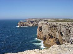
This cape is the southwesternmost point in Portugal. It forms the southwestern end of the E9 European Coastal Path, which runs for 5,000 km (3,100 mi) to Narva-Jõesuu in Estonia.Approximately six kilometers from the village of Sagres, the cape is a landmark for a ship traveling to or from the Mediterranean. The cliffs rise nearly vertically from the Atlantic to a height of 75 meters. The cape is a site of exuberant marine life and a high concentration of birds nesting on the cliffs, such as the rare Bonelli's eagle, peregrine falcons, kites, rock thrushes, rock pigeons, storks and herons.
The present lighthouse is 24 metres (79 ft) high and was built over the ruins of a 16th-century Franciscan convent in 1846. The statues of St. Vincent and St. Francis Xavier had been moved to church of Nossa Senhora da Graça on Point Sagres 3 kilometres (1.9 mi) away. This lighthouse, guarding one of the world's busiest shipping lanes, is among the most powerful in Europe (the most powerful being Phare du Creach on the French island of Ushant, off the coast of Brittany); its two 1,000 W lamps can be seen as far as 60 kilometres (37 mi) away.