
Postcode(s) 5604 Elevation 20 m | Postal code 5604 | |
 | ||
LGA(s) District Council of Tumby Bay | ||
Cape Hardy is a 20 m high dune capped granite headland on the eastern coast of Eyre Peninsula which protrudes westwards into Spencer Gulf in South Australia. It is located between the towns of Port Neill and Tumby Bay, 10 km north-northeast of Lipson Cove.
Contents
To the north and south of the cape are a series of low headland-bound white sandy beaches, backed by low dunes and farmland. Public access is limited to the Cape Hardy track and there are currently no facilities present. The surrounding beaches tend to face east to southeast and usually receive low swell and wind waves less than 1 m high.
History
The cape was named by British navigator Matthew Flinders during his explorations in 1802. The cape also bears the alternative name of Cap Portalis, so named by French explorer Nicolas Baudin in the same year.
In 1898, A. Poynton and William Tennant Mortlock, the members for the South Australian electorate of Flinders presented a petition to the Commissioner of Crown Lands (Hon. L. O'Loughlin) requesting the consideration of the establishment of a dog fence running west across Eyre Peninsula from Cape Hardy to Mount Misery. The petition was drafted in response to pastoralists' struggles to manage vermin in the Lower Eyre Peninsula region.
In April 1932, a piece of flotsam believed to be a hatch-cover from the missing ketch Vivid was found near Cape Hardy by Captain E. S. Hipkins of the ketch Nelcebee. The Vivid was last seen departing Tumby Bay on 9 April 1932. As of 2014, the ship's fate and that of its crew remain a mystery.
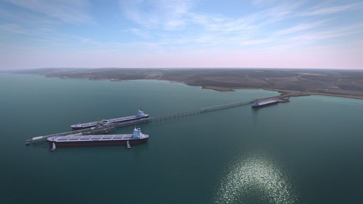
Proposed Development
In December 2012, Cape Hardy was first announced as the location for a prospective deep water port development. The port is planned to serve the export interests of mining company Iron Road Ltd and the development of the Central Eyre Iron Project. It received Major Project Status from the Government of South Australia in August 2013. In November 2015, Iron Road announced that an Environmental Impact Statement and Mining Lease application had been lodged with the South Australian Department of Planning, Transport and Infrastructure, which includes the port proposal.
Alternatives
Another prospective iron ore mining company, Centrex Metals Ltd, has proposed to construct an alternative port known as Port Spencer. Its site is located 9 km southwest of Cape Hardy, adjacent to Lipson Cove.