
Country Canada Elevation 350 m | Time zone AST (UTC-4) | |
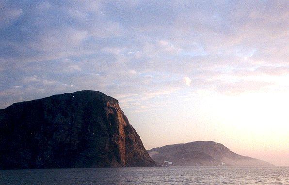 | ||
Cape Chidley is a headland located on the eastern shore of Killiniq Island, Canada at the northeastern tip of the Labrador Peninsula.
Contents
Map of Cape Chidley, Baffin, Unorganized, NU, Canada
Cape Chidley was named by English explorer John Davis on August 1, 1587 after his friend and fellow explorer John Chidley.
On October 22, 1943, the German submarine U-537 landed just south of Cape Chidley and set up Weather Station Kurt to collect data about the weather.
Originally, Cape Chidley was meant to be the site for a long-range radar station called "N-30." It was to fall within plans for the Pinetree Line, a series of radar stations across the 50th parallel. Supplies were moved to the site by ship during 1951-52, but in late 1952-early 1953 the site was moved to Resolution Island.
LocationEdit
Cape Chidley is located on the interprovincial boundary between the province of Newfoundland and Labrador and the territory of Nunavut. It forms the northernmost point of Labrador.
Sometimes spelled Cape Chudleigh, Cape Chidley is sometimes misrepresented as being located on the interprovincial border between Quebec and Newfoundland and Labrador. Newfoundland, having been a separate country at the time that Canada's Arctic islands were assigned in this manner, shared a boundary on Killiniq Island as the territory of Labrador included the entire Atlantic watershed of the Labrador Peninsula and its islands.
As such, the northern and western part of Killiniq Island under Nunavut's jurisdiction drains into Ungava Bay and the Hudson Strait. Thus Cape Chidley is also the terminus of the Northern Divide, which separates the Arctic Ocean watershed from the Atlantic Ocean watershed. (Some sources include Hudson Bay in the Atlantic Ocean watershed, though the Northern Divide has been long established and places Hudson Bay with the Arctic Ocean watershed.) The cape marks the south end of the entrance to the Hudson Strait, opposite Resolution Island.
The closest community to Cape Chidley was Port Burwell, Nunavut, until it was evacuated in 1978. Killiniq Island itself is separated from mainland North America by the narrow McLelan Strait.
The Torngat Mountains run along the coast of Labrador and terminate at Killiniq Island. The top of the knoll forming the headland at Cape Chidley has an elevation of 350 m (1,150 ft) making the cape considerably higher than either of its two flanking headlands.
The Cape Chidley Islands lie at the north end of the cape.