
 | ||
Similar Emmaus Nicopolis, Britannia Park, Ein Hemed National Park, Hurshat Tal National Park, Beit Guvrin National Park | ||
Canada Park (Hebrew: פארק קנדה, Arabic: كندا حديقة, also Ayalon Park,) is an Israeli national park stretching over 7,000 dunams (700 hectares), and extending from No man's land into the West Bank.
Contents
The park is North of Highway 1 (Tel Aviv-Jerusalem), between the Latrun Interchange and Sha'ar HaGai, and contains a Hasmonean fort, Crusader fort, other archaeological remains and the ruins of 3 Palestinian villages razed by Israel in 1967 after their inhabitants were expelled. In addition it has picnic areas, springs and panoramic hilltop views, and is a popular Israeli tourist destination, drawing some 300,000 visitors annually.
Establishment
After capturing the area in 1967 during the Six-Day War, Israel took over the Palestinian villages in the area, which were then razed on the orders of Israeli general Yitzhak Rabin, with 7,000–10,000 inhabitants expelled and 1,464 homes demolished. The lands of the 3 villages were confiscated and declared a closed area, and only declared 'public land' to be developed for a recreational park two years later in 1969. According to Meron Benvenisti the function of such re-afforestation projects like that at Canada Park was to confiscate Arab land in the Palestinian territories Israeli occupied after 1967. The JNF's reafforestation programme privileges pine over indigenous species, and, according to Ilan Pappé, the choice of a fast-growing species was dictated by considerations of rapidly hindering a return of refugees to their land, while, as evergreens, quickly concealing the demolished village sites with year round leafage.
Canada Park was established on the lands of the two Palestinian Arab villages Imwas and Yalo. The inhabitants were offered compensation but not allowed to return. Imwas, Yalo and Bayt Nuba were demolished as part of strategic plans to widen the Jerusalem corridor. Dayr Ayyub, also on the grounds of the park, had been partly destroyed during the fighting in 1948 and never rebuilt. The settlement of Mevo Horon was built on the lands of Bayt Nuba in 1970. Signage in the park indicates that it falls under the Department of Archaeology, Civil Administration of Judea and Samaria, Judea and Samaria being the Israeli terms for the West Bank. According to former Israel parliamentarian and peace activist, Uri Avnery, the creation of the park was tantamount to complicity in ethnic cleansing, and Canadian involvement in its creation a "cover to a war crime".
Canadian funding
In 1972, Bernard Bloomfield of Montreal, then President of JNF Canada, spearheaded a campaign among the Canadian Jewish community to raise $15 million ($80m in terms of 2010 values) for the park's establishment. The road leading to the park is named for John Diefenbaker, the former Canadian prime minister, who opened it in 1975. The project was completed in 1984. JNF Canada has continued fund-raising towards the maintenance of the park.
Residents' request to return
In 1976, Palestinian residents of Imwas, Yalo and Beit Nouba wrote to the Israeli prime minister Yitzhak Rabin asking for what they described as their "legitimate humanitarian right to return to the villages from which we were driven and expelled" in order to rebuild their houses without requesting compensation from Israel. They did not receive a reply. In 2007, the Israeli NGO Zochrot wrote to Israel's minister of defense, Ehud Barak, on behalf of the residents to ask why they could not return to their homes. In 2008, the minister's office informed them that "The return of the village inhabitants [was] not allowed for security considerations". In 2013 the Palestinian National Authority's Negotiations Affairs Department launched a campaign to have the 50-km. contiguous to the Green Line restored to it as 'vital and integral part of the State of Palestine as defined by the 1967 border.'
Features
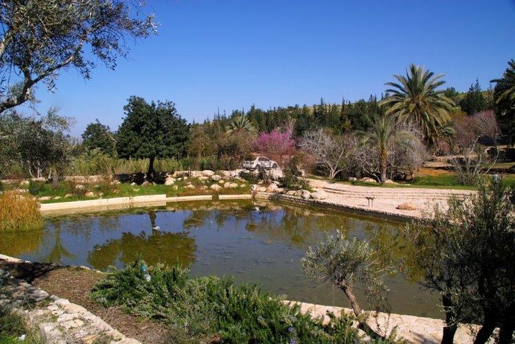
Canada Park covers an area of 7,000 dunams. It is filled with wooded areas, walking trails, water features and archaeological sites. Trees in the park include olive, carob, pomegranate, pine and almond. The area is also home to a range of wildlife from lizards and turtles to gray ravens and blue jays. Historical ruins on the grounds of the park include a Roman bathhouse, a Hasmonean cemetery, and a Crusader fortress (Castellum Arnaldi). Two Second Temple-era ritual baths were also discovered there. At the foot of one of the hills that overlooks the city of Modi'in is a large reservoir built by the Jewish National Fund for irrigating local fields.
In the middle of the park is a forest planted to commemorate over 300 American and Canadian Jews who died in Israel's wars or were victims of terror. An annual memorial ceremony is organized by the Association of Americans and Canadians in Israel (AACI). In 2011, the ceremony was attended by the US Ambassador to Israel Daniel Shapiro.