
- location west of Lorne - elevation 0 m (0 ft) - elevation 0 m (0 ft) Basin area 589 km² | - elevation 698 m (2,290 ft) - location Camden Head Area 32.2 km² | |
 | ||
- location Watson Taylors Lake, near Laurieton Sources | ||
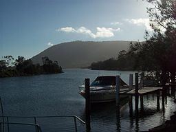
Camden Haven River, an open and trained intermediate wave dominated barrier estuary, is located in the Mid North Coast region of New South Wales, Australia.
Contents
Map of Camden Haven River, New South Wales, Australia
Course and features
Camden Haven River upper catchment starts at the two south eastern creeks at Edge. The merged flow of the two rivers, together with the outflow of Queens Lake spills into the Tasman Sea of the South Pacific Ocean. The river descends 698 metres (2,290 ft) over its 72 kilometres (45 mi) course.
Camden Haven River is transversed by the Pacific Highway north of the village of Rossglen, between Coopernook and Kew.
References
Camden Haven River Wikipedia(Text) CC BY-SA