
Local time Tuesday 6:58 PM | ||
 | ||
Population 7,177 (2011 census)16,449 (2015) Weather 22°C, Wind S at 29 km/h, 62% Humidity Points of interest Kattang Nature Reserve, Grants Beach | ||
Camden haven tourism www visitcamdenhaven com au
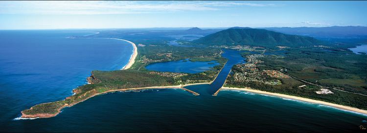
Camden Haven is a small harbour in the Mid North Coast region of New South Wales, Australia, approximately 30 km south of the major regional centre of Port Macquarie. The harbour is located where the Camden Haven River empties into the Tasman Sea.
Contents
Map of Camden Haven NSW, Australia
Camden Haven is also the name given to a group of settlements located on the shores of Camden Haven and in the rural hinterland. Laurieton, located on the harbour's western shore, is the largest town and the commercial centre for the Camden Haven district.
Other communities in the immediate vicinity of the harbour include North Haven and Dunbogan. Lakewood is a new residential area west of Laurieton, while further inland are the villages of Kew on the Pacific Highway and Kendall on the North Coast railway line. The estimated urban population of this broader area was 16,449 at June 2015.
The Camden Haven region is bordered on the west by the Comboyne plateau. The district consists of fertile, well-watered valleys punctuated by several large mountains, notably the Three Brothers. The region's economy is based on tourism, fisheries, forestry and oyster farming.