
Population 833 (2011 census) Local time Sunday 12:32 PM | Postcode(s) 2439 Postal code 2439 | |
 | ||
Weather 29°C, Wind NE at 10 km/h, 38% Humidity | ||
Kendall is a town on the Mid North Coast of New South Wales, Australia.
Contents
Map of Kendall NSW 2439, Australia
History
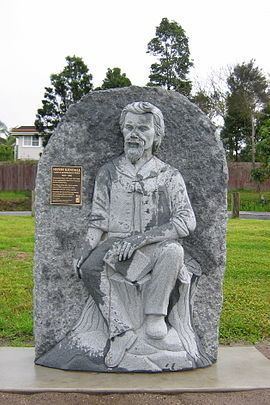
Kendall was originally named Camden Heads, as it is located on the Camden Haven River. It was renamed Kendall, in 1891, after the Australian poet Henry Kendall, and not, as some tourists suspect, after the similarly-spelled ancient town of Kendal in the County of Cumbria in England. Henry Kendall lived in the area from 1875 to 1881 when he was the first Forest Inspector for New South Wales.
The original residents of the Kendall area were the Birpai people.
Kendall is located 3 kilometres from Kew and 36 kilometres southwest of Port Macquarie via the Pacific Highway. It's one of seven villages that make up the Camden Haven region of the Port Macquarie/Hastings Local Government Area. At the 2011 census, it had a population of 833 people.
Transport
Kendall railway station is served by three XPT services daily from Sydney on the North Coast railway line.