
Country United States | ||
 | ||
Similar Gavins Point Dam, Spirit Mound, Lewis & Clark State Recreation, Niobrara State Park, Fort Atkinson | ||
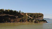
Calumet Bluff is a hill about 180 feet high overlooking the Missouri River in Cedar County, Nebraska where the Lewis and Clark Expedition held its first council with the Sioux Indians for two days in 1804. Today the Bluff forms the right or south abutment of the Gavins Point Dam. The U.S. Army Corps of Engineers maintains the Lewis and Clark Visitor Center on Calumet Bluff next to the dam.
Contents
- Map of Calumet Bluff Nebraska 68730 USA
- History
- Lewis and Clark Visitor Center
- Further Information
- References
Map of Calumet Bluff, Nebraska 68730, USA
History
The Lewis and Clark Expedition's Corps of Discovery camped below Calumet Bluff during the period of August 28 to September 1, 1804. In his diary, Clark noted the bluff was "Called White Bear Clift, one of those animals haveing been killed in a whole in it[sic]." The bluff is often called "White Bear Cliff" in historical records, but is now more commonly called Calumet Bluffs. A "Calumet" refers to a peace pipe, [this is a misinterpretation, at that time it was a name given to a Golden Eagle; eagles nest on bluffs and their feathers where probably on the peace pipe]. To this day, the bluff matches Lewis and Clark's description of it as "composed of a yellowish red, and brownish clay as hard as chalk."
It was at Calumet Bluff that the Corps had their first encounter with the Yankton-Sioux Tribe on August 30, 1804, meeting with them for two days. Folklore claims that a male child was born into the Yankton tribe while Lewis and Clark were meeting with them on Calumet Bluff. When he heard this, Capt. Lewis had the child brought forward and wrapped him in an American flag. Lewis predicted that the boy would become a leader of his tribe and a friend of the white men. The child grew up to be the famous Yankton Chief Padaniapapi, or "Struck By The Ree."
Lewis and Clark Visitor Center
The Lewis and Clark Visitor Center at Calumet Bluff is located just downstream from the Gavins Point Powerplant in Crofton, Nebraska. It overlooks the Missouri River, the Gavins Point Dam, and the Lewis and Clark Lake to the West. Exhibits and theater programs cover the history of the Expedition and the geology, exploration, settlement and natural history of the Missouri River region. Outside the Center, the Dorian Prairie Garden depicts common prairie plants and explains their uses by Native Americans. There is also bookstore in the Center.