
Counties: Stanislaus | Length 7.631 km | |
 | ||
County | ||
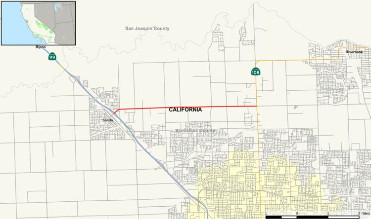
State Route 219 is a state highway in the U.S. state of California in Stanislaus County. It serves as a connector between State Route 99 with State Route 108.
Contents
Map of CA-219, Modesto, CA 95356, USA
Route description
The route begins at an interchange with SR 99 in Salida. It then heads east, out of the city, as Kiernan Avenue. The east end of SR 219 is at State Route 108 in Stanislaus County, due north of Modesto. Other than Salida, the route runs through rural farmland and does not connect between any population centers.
History
In 2009, 2.25 miles (3.62 km) of SR 219 were expanded to 4 lanes with a center median. As of November 2010, a study is underway to determine the feasibility of reconstructing the State Route 99/State Route 219 interchange to handle projected future demand.
In January, 2015 the old Kiernan Avenue overpass for the SR99 interchange was demolished, to make way for the new SR 99 interchange. Traffic was shifted over to a small portion of the new interchange that had been completed during the demolition, so that traffic would still be able to pass over SR 99.
June 20, 2016, marked the completion of a $42 million, three-year project to build an interchange with SR 99 in Salida. $33.4 million was paid for by the state through a bond measure while the remainder came from fees charged by Stanislaus County to developers. The new interchange provided a wider overpass, more room for entering traffic and a new bike lane.
Major intersections
Except where prefixed with a letter, postmiles were measured on the road as it was in 1964, based on the alignment that existed at the time, and do not necessarily reflect current mileage. R reflects a realignment in the route since then, M indicates a second realignment, L refers an overlap due to a correction or change, and T indicates postmiles classified as temporary (for a full list of prefixes, see the list of postmile definitions). Segments that remain unconstructed or have been relinquished to local control may be omitted. The entire route is in Stanislaus County.