
Length 59.5 km | ||
 | ||
Major cities | ||
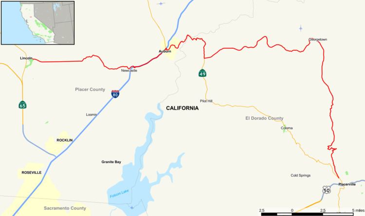
State Route 193 is a split-section California State Highway consisting of two sections: an east–west arterial road running from Lincoln to Newcastle, just west of Auburn. The other section is a loop to the east off Route 49, heading eastward from Cool to Georgetown, then turning south to rejoin Route 49 just north of Placerville.
Contents
Map of CA-193, California, USA
Route description
SR 193 is part of the California Freeway and Expressway System.
SR 193 begins at the eastern city limits of Lincoln. The route formerly began at a junction with what was then SR 65 (now Lincoln Boulevard) in Lincoln, and was known as McBean Park Drive (SR 65 has since relocated to a new bypass alignment). The portion within the city of Lincoln was relinquished to the city in February 2011. After leaving the city of Lincoln, SR 193 becomes known as Lincoln Newcastle Highway and enters rural Placer County. A few miles later, SR 193 passes over the tunnel containing Taylor Road before heading east on Taylor Road to an interchange with I-80 in Newcastle.
SR 193 runs concurrently on I-80 eastbound into the city of Auburn, where it then leaves I-80 and runs concurrently with SR 49. These concurrencies are unsigned. SR 193 resumes as Georgetown Road, heading east from SR 49, the town of Cool, and the Auburn State Recreation Area. The highway passes through the towns of Fords Corner, Greenwood, and Georgetown before turning south and encountering the town of Kelsey after several miles. SR 193 terminates at the northern city limits of Placerville at its second junction with SR 49.
Major intersections
Except where prefixed with a letter, postmiles were measured on the road as it was in 1964, based on the alignment that existed at the time, and do not necessarily reflect current mileage. R reflects a realignment in the route since then, M indicates a second realignment, L refers an overlap due to a correction or change, and T indicates postmiles classified as temporary (for a full list of prefixes, see the list of postmile definitions). Segments that remain unconstructed or have been relinquished to local control may be omitted. The numbers reset at county lines; the start and end postmiles in each county are given in the county column.