
Existed: 1964 – present Length 22.75 km | Counties: Kern Constructed 1964 | |
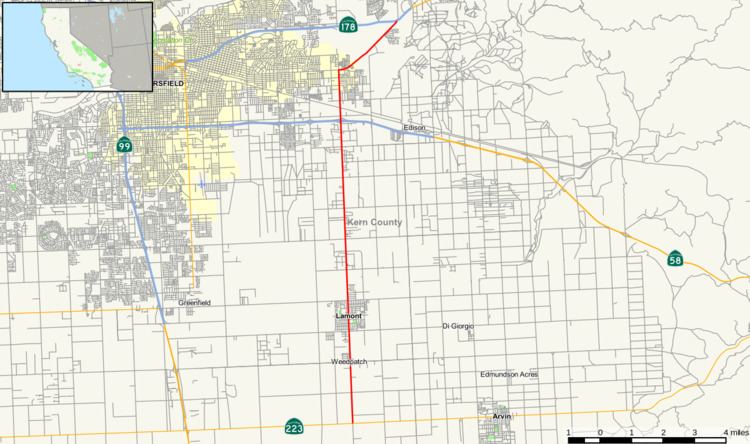 | ||
State Route 184 (SR 184) is a state route in Kern County, California, locally known as “Weedpatch Highway.” It is mainly a 2-lane conventional highway, expanding to four lanes in Bakersfield, and Lamont. It connects the local agricultural land south of Bakersfield, and east of SR 99/I-5, to a major east/west freeway, SR 58. The freeway connects the San Joaquin Valley to all points southeast. It also connects to SR 178 (Kern Canyon Road), a highway which runs from Bakersfield to the Kern Valley region, and SR 223 (Bear Mountain Boulevard), which connects I-5 (Westside Freeway) to SR 58 on a route south of Bakersfield. SR 184 southern terminus is with Wheeler Ridge Rd, a county road. Although not a truck route, it is the only north/south road south of Bakersfield that directly connects to I-5, which runs east of SR 99. Its connection is with the Golden State Freeway section south of SR 99.
Contents
Map of CA-184, California, USA
This route is part of the California Freeway and Expressway System.
Route description
SR 184 starts at the intersection of SR 223 (Bear Mountain Boulevard) and Wheeler Ridge Road. It travels north, through relatively flat agricultural land. It crosses through the towns of Weedpatch, and Lamont. The highway continues north, and crosses its major junction with SR 58. At the junction, the road’s name changes to Morning Drive. It then enters the rural, but growing, eastern portion of Bakersfield. At the intersection of Morning Drive and Niles Street/Kern Canyon Road, the route turns right onto Kern Canyon Road. The route turns northeast, as it travels through open grassland. It terminates at SR 178 (Kern Canyon Road) near the old Mesa Marin Raceway.
In describing the route for SR 184, it is also important to discuss Wheeler Ridge Rd, the county route that starts at the southern end of the route. It travels straight south, through agricultural land to I-5 (Golden State Freeway) south of SR 99. This provides an eastern bypass to the busy SR 99.
History
SR 184 was adopted as a state route in 1933 as Legislative Route 143. It was an unsigned highway running from LRN 140 (current SR 223, Bear Mountain Boulevard), to LRN 57 (current SR 178, Kern Canyon Rd.). The route definition has changed little since that time. In 1964, during the renumbering of California routes, LRN 143 changed to SR 184, and became a signed route. In 1968, with the opening of SR 178 freeway in Bakersfield, SR 184 was extended northeast, along the old SR 178 alignment to a new connection just east of the old Mesa Marin Raceway. This was where the new alignment for SR 178 ended. This connection was only a temporary connection, because a Morning Drive extension to a new interchange at SR 178 is currently under construction and is planned to be completed in 2016. SR 184 is planned to be rerouted onto this new alignment.
Major intersections
Except where prefixed with a letter, postmiles were measured on the road as it was in 1964, based on the alignment that existed at the time, and do not necessarily reflect current mileage. R reflects a realignment in the route since then, M indicates a second realignment, L refers an overlap due to a correction or change, and T indicates postmiles classified as temporary (for a full list of prefixes, see the list of postmile definitions). Segments that remain unconstructed or have been relinquished to local control may be omitted. The entire route is in Kern County.