
Country United States County Fresno County Local time Sunday 3:02 AM | State California Elevation 585 m | |
 | ||
Weather 11°C, Wind E at 6 km/h, 73% Humidity | ||
Hang gliding tollhouse california 1977
Tollhouse (formerly, Toll House) is an unincorporated community in Fresno County, California. It lies at an elevation of 1919 feet (585 m). Tollhouse is located in the Sierra Nevada, 7 miles (11 km) southwest of Shaver Lake.
Contents
Map of Tollhouse, CA 93667, USA
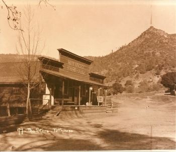
The town was created in the 1860s around a lumber mill. The name "tollhouse" comes from the fact that the community was also built up in connection to a now-defunct toll road running up the steep slopes of Sarver Peak to Pineridge and housed a toll house.
The ZIP Code is 93667, and the community is inside area code 559.
The first post office opened in Tollhouse in 1876, closed in 1884, re-opened in 1885. The last toll on the toll road was collected in 1878. Tollhouse is home to many small mountains.
The small towns of Auberry, CA, Prather, CA, and Shaver, CA are in a close proximity to Tollhouse as well.
Tollhouse is the tribal headquarters for the Cold Springs Rancheria of Mono Indians of California.
Notable residents
Notable current and former residents of Tollhouse include: