
Traversed by SR 168 | Elevation 2,229 m | |
 | ||
Similar White Mountains, Inyo Mountains, White Mountain Peak, Ancient Bristlecone Pine Forest, Boundary Peak | ||
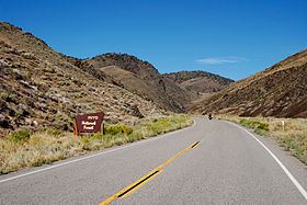
Westgard Pass (el. 7,313 ft. / 2,229 m.) is a narrow gap between the White Mountains and Inyo Mountains ranges in the Basin and Range Province of eastern California. Westgard Pass lies entirely within the Inyo National Forest, in northern Inyo County, California.
Contents
Map of Westgard Pass, California, USA
State Route 168 crosses the pass, connecting the Owens Valley to Deep Springs Valley. Route 168 is the only (paved) east-west route across the Inyo-White Mountains. The highway is known for its pristine scenery and grand vistas.
History
The pass was named after Anton L. Westgard, the Norwegian-born Vice President and Director of Transcontinental Highways of the National Highways Association. Inyo County and the State of California bestowed the honor on Westgard after his successful transcontinental journey by automobile in 1911. Westgard, nicknamed "The Pathfinder" was appointed by Federal Highway Administration Director Logan Page to attempt the trek as research for appropriate locations for the first transcontinental highways. This initial field survey ultimately led to what would eventually become the Lincoln Highway.
Although not the first transcontinental voyage by motorized vehicle, Westgard claimed to be the first to have completed the journey by truck, his being a 37-horsepower "Pioneer Freighter".