
Length 74.8 km | ||
 | ||
Major cities | ||
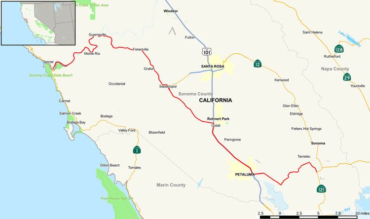
State Route 116 (SR 116) is a state highway in the U.S. state of California in Sonoma County. The route runs from State Route 1 on the Pacific coast near Jenner to State Route 121 south of Sonoma.
Contents
Map of CA-116, California, USA
Route description
This route is part of the California Freeway and Expressway System and is eligible for the State Scenic Highway System. However, it is only a scenic highway as designated by Caltrans from SR 1 to the Sebastopol city limit.
State Route 116 proceeds east along the north bank of the Russian River, from State Route 1 to Guerneville, passing through Duncans Mills, Monte Rio, and Guernewood Park.
At the intersection of the Guerneville Bridge, the route turns southeast and passes through Forestville. The road itself continues eastward, but beyond the bridge the road is called River Road until it reaches Hwy 101. The section connecting Guerneville and Forestville is known as Pocket Canyon Rd., named for the canyon it passes through. For the 4 blocks it passes through Forestville it is called Front Street. Front St. is an east-west street, but it veers south again towards Graton and Sebastopol. Here it is called Gravenstein Hwy North until Covert St. in Sebastopol. There it undergoes another name change: Healdsburg Avenue. But it doesn't last long. Heading south (right turn), it becomes North Main Street for two blocks where it intersects Bodega Highway State Route 12), whereupon it becomes South Main Street. When the one-way street becomes a two-way street again, it becomes Gravenstein Hwy South all the way to Cotati where it becomes Hwy 101 South U.S. Route 101 until it runs along Lakeville Highway to Stage Gulch Rd, where it makes a left turn east toward Sonoma, crossing the Sonoma Mountains directly north of Tolay Lake and descending into the Sonoma Valley to its terminus at State Route 121.
Major intersections
Except where prefixed with a letter, postmiles were measured on the road as it was in 1964, based on the alignment that existed at the time, and do not necessarily reflect current mileage. R reflects a realignment in the route since then, M indicates a second realignment, L refers an overlap due to a correction or change, and T indicates postmiles classified as temporary (for a full list of prefixes, see the list of postmile definitions). Segments that remain unconstructed or have been relinquished to local control may be omitted. The entire route is in Sonoma County.