
Elevation 59 ft (18 m) Area code(s) 707 Exchange: 869 Zip code 95446 | County Sonoma FIPS code 06-31470 Population 4,534 (2010) | |
 | ||
Weather 9°C, Wind N at 5 km/h, 83% Humidity Points of interest Armstrong Redwoods State Nat, Austin Creek State Rec, Pee Wee Golf & Arcade, Guerneville River Park | ||
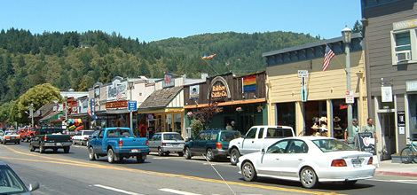
Guerneville (pronounced /ˈɡɜːrnvɪl/, formerly /ˈɡɜːrniːvɪl/) is an unincorporated community and census-designated place in the Russian River Valley of Sonoma County, California, United States. The town is historically known for the logging community, formed in the late 1800s. Guerneville is also known for its natural beauty, liberal atmosphere, and proximity to wine-tasting and redwood forests. It was founded by the Guerne family in the 1850s.
Contents
- Map of Guerneville CA 95446 USA
- History
- Geography
- Climate
- 2010
- 2000
- Tourism
- LGBT community
- Parks and recreation
- Government
- Local politics
- Education
- Media
- Filmed in Guerneville
- Additional reading
- References
Map of Guerneville, CA 95446, USA
History
Guerneville is built adjacent to the Russian River. Redwoods grew in the riverbed with such vigor that just a few centuries ago, the valley had the greatest biomass density on the planet, according to local lore. The local Pomo Indians used the area as a summer camp and called it "Ceola" (/ˈsiːoʊleɪ/ or cee-oh-lay) which meant "shady place." Except for a large, beautiful stand of truly ancient trees preserved in the Fife Creek watershed, now the centerpiece of Armstrong Woods Park, many of the trees were logged in the 19th century, giving rise to the first English name for the place – "Stumptown." The annual town parade still commemorates the old place name by calling itself "Stumptown Days." The present name Guerneville was introduced to honor Swiss immigrant George Guerne, a local businessman of the 19th century who owned the town's sawmill. By 1870, there was a U.S. Post Office in Guerneville; it was listed by the name "Guerneville". Although locals may be found selling T-shirts that say "Don't call it Guerneyville", many have called the town "Guerneyville" in spelling and pronunciation since the 1800s. The extensive redwood forests on the surrounding mountains are less than 200 years old, having been replacement plantings for much of the logging done in the 19th century.
The area became popular with wealthy vacationers from San Francisco and surrounding communities in the late 19th century. The San Francisco and North Pacific Railroad linked the town to the Ferries of San Francisco Bay in 1877. Even with the demise of train service in the late 1930s, the area's resorts remained popular with vacationers who came by automobile through the 1950s. A local movie theater, the River, was built near the beach and showed double features throughout the 1950s and 1960s. The coming of jet airplane travel in the 1960s marked a period of decline for many of the older resorts. Winter floods in 1964 caused a further decline in business conditions. A renaissance took place in the late 1970s as large numbers of gay entrepreneurs from San Francisco identified the area as a prime recreational destination for weekends. Many older resorts benefited from increased tourism, and the town's businesses began to thrive.
Geography
Guerneville is located in western Sonoma County, along the Russian River on State Route 116, between Monte Rio to the west and Forestville to the east.
The CDP has a total area of 9.88 sq mi (25.6 km2). Of that, 9.71 sq mi (25.1 km2) is land and 0.17 sq mi (0.4 km2) (1.72%) is water.
Climate
Guerneville has cool, wet winters and warm, dry summers, a climate typical of northern coastal California. Although rainfall is rare during the summer months, fog often comes up the river from the Pacific Ocean, producing enough condensation to create "fog drip," which sustains the numerous redwood trees, ferns, and other vegetation.
The National Weather Service reports that Guerneville has an average annual rainfall of 49.15 inches (1,248 mm). Measurable precipitation occurs on an average of 73 days each year. The wettest year was 1970 with 70.20 inches (1,783 mm) and the driest year was 1949 with 31.34 inches (796 mm). The most rainfall in one month was 29.08 in January 1970. The most rainfall in 24 hours was 8.40 inches (213 mm) on February 8, 1960.
Although no official temperature records exist for Guerneville, the nearby town of Graton has average January temperatures ranging from 35.7 °F (2.1 °C) to 56.1 °F (13.4 °C), and July temperatures from 48.4 °F (9.1 °C) to 83.5 °F (28.6 °C). There are an average of 28.7 days annually with highs of 90 °F (32 °C) or higher and 44.7 days annually with lows of 32 °F (0 °C) or lower. The record high temperature was 113 °F (45 °C) on July 14, 1972, and the record low temperature was 14 °F (−10 °C) on December 22, 1990. Other nearby cooperative National Weather Service stations are in Occidental, Cazadero, and Fort Ross.
2010
The 2010 United States Census reported that Guerneville had a population of 4,534. The population density was 458.9 people per square mile (177.2/km²). The racial makeup of Guerneville was 3,926 (86.6%) White, 31 (0.7%) African American, 68 (1.5%) Native American, 47 (1.0%) Asian, 12 (0.3%) Pacific Islander, 226 (5.0%) from other races, and 224 (4.9%) from two or more races. Hispanic or Latino (of any race) were 553 persons (12.2%).
The Census reported that 99.1% of the population lived in households and 0.9% lived in non-institutionalized group quarters.
There were 2,305 households, out of which 407 (17.7%) had children under the age of 18 living in them, 583 (25.3%) were opposite-sex married couples living together, 197 (8.5%) had a female householder with no husband present, 112 (4.9%) had a male householder with no wife present. There were 175 (7.6%) unmarried opposite-sex partnerships, and 176 (7.6%) same-sex married couples or partnerships. 984 households (42.7%) were made up of individuals and 235 (10.2%) had someone living alone who was 65 years of age or older. The average household size was 1.95. There were 892 families (38.7% of all households); the average family size was 2.74.
The population was spread out with 643 people (14.2%) under the age of 18, 306 people (6.7%) aged 18 to 24, 1,042 people (23.0%) aged 25 to 44, 1,932 people (42.6%) aged 45 to 64, and 611 people (13.5%) who were 65 years of age or older. The median age was 48.2 years. For every 100 females there were 119.8 males. For every 100 females age 18 and over, there were 119.3 males.
There were 3,343 housing units at an average density of 338.4 per square mile (130.6/km²), of which 56.2% were owner-occupied and 43.8% were occupied by renters. The homeowner vacancy rate was 3.6%; the rental vacancy rate was 7.7%. 56.2% of the population lived in owner-occupied housing units and 42.9% lived in rental housing units.
2000
As of the census of 2000, there were 2,441 people, 1,097 households, and 523 families residing in the CDP. The population density was 743/sq mi (287/km²). There were 1,463 housing units at an average density of 445/sq mi (172/km²). The racial makeup of the CDP was 87.42% White, 0.70% African American, 1.07% Native American, 0.61% Asian, 0.20% Pacific Islander, 4.51% from other races, and 5.49% from two or more races. Hispanic or Latino of any race were 14.54% of the population.
There were 1,097 households out of which 22.0% had children under the age of 18 living with them, 28.4% were married couples living together, 14.1% had a female householder with no husband present, and 52.3% were non-families. 34.8% of all households were made up of individuals and 8.5% had someone living alone who was 65 years of age or older. The average household size was 2.17 and the average family size was 2.86.
In the CDP, the population was spread out with 19.7% under the age of 18, 7.5% from 18 to 24, 30.2% from 25 to 44, 32.3% from 45 to 64, and 10.4% who were 65 years of age or older. The median age was 42 years. For every 100 females there were 108.5 males. For every 100 females age 18 and over, there were 109.3 males.
The median income for a household in the CDP was $37,266, and the median income for a family was $45,875. Males had a median income of $32,350 versus $31,429 for females. The per capita income for the CDP was $22,793. About 13.5% of families and 13.1% of the population were below the poverty line, including 25.6% of those under age 18 and 5.4% of those age 65 or over.
As of 2000 90% of people from Guerneville speak primarily English while 10% do not. Of these, 6% speak Spanish, 1% speak Russian, 1% speak French, 1% speak German, 1% speak Portuguese, less than 1% speak "other West Germanic languages," Tagalog and Thai.
Tourism
Guerneville includes a plaza in the town center with permanent chess tables, and small shops. A public beach area along the Russian River is used for fishing, swimming, boating, and sunbathing.
LGBT community
Guerneville is a vacation destination, and hosts an annual Sonoma County Pride Parade and Celebration the first Sunday in June, Lazy Bear Weekend in late July or early August, Polar Bear Weekend, in mid-January (gay bear charity events for the LGBT community), and Women's Weekend in the summer. Guerneville is also home to the Russian River Sisters of Perpetual Indulgence, a chapter of the Sisters of Perpetual Indulgence, which holds entertaining events in various venues along the Russian River, including monthly bingo games.
There are several LGBT-friendly clubs and bars in Guerneville, such as Rainbow Cattle Company, with Seth Montfort, composer and classical pianist, performing both solo and with "The Mortuary Orchestra of Guerneville" (formerly San Francisco Concerto Orchestra) at the "Music Inside Out & Center."
Parks and recreation
Places of interest include Armstrong Redwoods State Natural Reserve and the adjacent Austin Creek State Recreation Area, the Russian River with its meandering flow and wildlife, Johnson's Beach, which hosts the Russian River Jazz and Blues festival and provides summer swimming and boating, and the close proximity of the Pacific Ocean.
Government
In the California State Legislature, Guerneville is in the 2nd Senate District, represented by Democrat Mike McGuire, and in the 2nd Assembly District, represented by Democrat Jim Wood.
In the United States House of Representatives, Guerneville is in California's 2nd congressional district, represented by Democrat Jared Huffman.
Local politics
Guerneville is politically liberal, consistent with most of western Sonoma County politics.
Education
The Guerneville School District includes the Guerneville School, a K-8 school, established in 1949.
Media
Guerneville/lower Russian River events receive daily coverage by the Santa Rosa Press Democrat's "hyperlocal" online Towns section.
Guerneville is the home of radio station KGGV-FM, 95.1 The Bridge.
The Russian River area occasionally appears in local and/or national news due to significant winter flooding, the worst of which occurred in 1986. Because much of the housing is elevated, thanks in large part to FEMA grants, floods no longer have the impact they once did and recovery for most residents and businesses is much faster than in earlier times. The effects of floods are mitigated by the extensive upstream floodplain storage capacity of the Laguna de Santa Rosa.
Filmed in Guerneville
Guerneville's older metal truss bridge can be filmed from the newer bridge, and made an appearance in the movie Mumford as a location for people to walk and talk in idyllic settings. The independent film Deep Dark Canyon was filmed in Guerneville. Surrounding communities were also regular filming locations for the 1960s television series Combat!