
Country United States County Gordon Time zone Eastern (EST) (UTC-5) Local time Monday 8:39 AM Area code Area codes 706 and 762 | Incorporated (city) January 1852 Elevation 201 m Population 15,899 (2013) | |
 | ||
ZIP codes 30701, 30703 (PO Boxes) Weather 14°C, Wind SE at 10 km/h, 68% Humidity Area 38.85 km² (38.59 km² Land / 21 ha Water) | ||
Calhoun is a city in Gordon County, Georgia, United States. As of the 2010 census, the city had a population of 15,650, up from 10,667 at the 2000 census. Calhoun is the county seat of Gordon County.
Contents
- Map of Calhoun GA USA
- History
- Geography
- Climate
- Demographics
- Museums and other points of interest
- Calhoun City School District
- Gordon County School District
- Private school
- Seventh day Adventist
- Higher education
- Radio and TV
- Notable people
- References
Map of Calhoun, GA, USA
History
Calhoun was a part of the Cherokee Nation (including New Echota, capital of the Cherokee Nation) until December 29, 1835. Cherokee leaders such as The Ridge and William Hicks had developed numerous productive farms in the fertile Oothcaloga Valley. When the Cherokee refused to give up the remainder of their lands under the Indian Removal Act, after years of land cessions to the United States for white settlers in Georgia, North Carolina and Tennessee, President Andrew Jackson sent US troops to the northern region of Georgia to force most of the tribe to move to Indian Territory west of the Mississippi River, most notably present-day Oklahoma. (See more information on Trail of Tears.)
In December 1827, Georgia had already claimed the Cherokee lands that became Gordon County and other counties. A small town called "Dawsonville" was created and founded in the Gordon County, named for the owner of an early general store. Dawsonville was later renamed "Calhoun" to honor U.S. Senator John C. Calhoun, following his death in 1850.
Gordon County's inferior court called an election for the selection of the county seat, offering voters a choice between a site on the Western & Atlantic Railroad (near Adairsville) or a site more centrally located within the county. Voters chose a site along the railroad, so the inferior court designated Calhoun as county seat in 1851. The legislature incorporated Calhoun in an act approved on January 12, 1852.
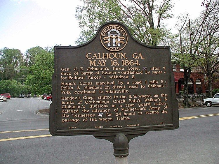
On January 5, 1861, Georgia seceded from the Union as a prelude to the American Civil War. Calhounians joined the Confederacy. Most warfare took place elsewhere, but on May 16, 1864, Calhoun was near where the Union General William Tecumseh Sherman and Confederate General Joseph E. Johnston postured before the Battle of Adairsville during Sherman's Atlanta Campaign. Oakleigh, the home of Dr. Wall, was used by Sherman as his headquarters at that time.
A tornado on March 20, 1888, leveled much of Calhoun. A devastating fire on October 23 of that year destroyed most of what remained.
Geography
Calhoun is located west of the center of Gordon County at 34°30′0″N 84°56′33″W (34.499898, -84.942584), along the Oostanaula River where it is joined by Oothkalooga Creek. It is part of the Coosa River/Alabama River watershed.
U.S. Route 41 passes through the center of town as Wall Street, and Interstate 75 runs along the eastern edge of the city, with access from Exits 310, 312, 315, 317, and 318. I-75 leads north 49 miles (79 km) to Chattanooga, Tennessee, and south 68 miles (109 km) to Atlanta. US-41, running parallel to I-75, leads north 5 miles (8.0 km) to Resaca and south 10 miles (16 km) to Adairsville. Georgia State Route 156 runs west out of town as West Line Street, leading 18 miles (29 km) to Armuchee, and heads east out of town as Red Bud Road, leading 8 miles (13 km) to Red Bud. Georgia State Route 373 (East Line Street and Dews Pond Road) leads east 8 miles (13 km) to Cash. Georgia State Route 136 (North River Street) leads northwest 30 miles (48 km) to LaFayette. Georgia State Route 53 passes through the southern part of Calhoun, leading east 15 miles (24 km) to Fairmount and southwest 22 miles (35 km) to Rome.
According to the United States Census Bureau, the city of Calhoun has a total area of 15.0 square miles (38.9 km2), of which 14.9 square miles (38.7 km2) is land and 0.1 square miles (0.2 km2), or 0.64%, is water.
Climate
The climate in this area is characterized by relatively high temperatures and evenly distributed precipitation throughout the year. According to the Köppen Climate Classification system, Calhoun has a humid subtropical climate, abbreviated "Cfa" on climate maps.
Demographics
As of the census of 2000, there were 10,667 people, 4,049 households, and 2,672 families residing in the city. The population density was 915.4 inhabitants per square mile (353.5/km²). There were 4,298 housing units at an average density of 368.8 per square mile (142.4/km²). The racial makeup of the city was 77.91% White, 7.56% African American, 0.42% Native American, 1.00% Asian, 0.14% Pacific Islander, 11.61% from other races, and 1.36% from two or more races. 17.07% of the population was Hispanic or Latino of any race.
There were 4,049 households out of which 30.9% had children under the age of 18 living with them, 47.8% were married couples living together, 13.9% had a female householder with no husband present, and 34.0% were non-families. 28.8% of all households were made up of individuals and 12.0% had someone living alone who was 65 years of age or older. The average household size was 2.56 and the average family size was 3.07.
In the city, the population was spread out with 24.2% under the age of 18, 11.2% from 18 to 24, 31.0% from 25 to 44, 20.1% from 45 to 64, and 13.5% who were 65 years of age or older. The median age was 34 years. For every 100 females there were 98.9 males. For every 100 females age 18 and over, there were 96.7 males.
The median income for a household in the city was $33,618, and the median income for a family was $42,310. Males had a median income of $27,616 versus $25,018 for females. The per capita income for the city was $19,887. About 12.5% of families and 16.8% of the population were below the poverty line, including 20.8% of those under age 18 and 19.1% of those age 65 or over.
Museums and other points of interest
Calhoun City School District
The Calhoun City School District serves preschool to grade twelve, and consists of two elementary schools, a middle school, and a high school, separate from the county school district. The district has 166 full-time teachers and over 2,666 students.
Gordon County School District
The Gordon County School District holds grades pre-school to grade twelve, that consists of six elementary schools, two middle schools and two high schools, serving the area outside the city limits. The district has 365 full-time teachers and over 6,259 students.
Private school
Seventh-day Adventist
Higher education
Radio and TV
Although well outside of metro Atlanta, Calhoun is considered part of the Atlanta television market, the ninth-largest DMA according to Nielsen Media Research. Cable TV service is offered through Comcast Cable, which provides one public, educational, and government access (PEG) cable TV channel named WEBS cable 3.
There are now four radio stations having Calhoun as their city of license:
Many other stations from Rome, Atlanta, and Chattanooga are also available across northwest Georgia, though reception of these often depends on weather.
There is also a semi-weekly newspaper, The Calhoun Times