
Official name Barragem do Cabril Purpose Power Opening date 1954 Construction began 1950 | Status Operational Address R. 9 6, Portugal | |
 | ||
Similar Bouçã Dam, Castelo de Bode Dam, Santa Luzia Dam, Aguieira Dam, Fratel Dam | ||
3d laser scanning cabril dam
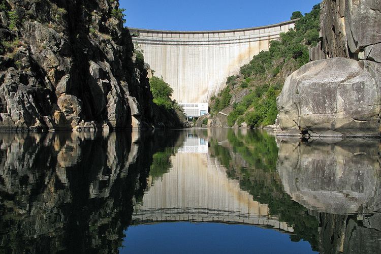
Cabril Dam (Portuguese: Barragem do Cabril) is a concrete double curvature arch dam on the Zêzere River, where the river forms the border line between the districts of Castelo Branco and Leiria. It is located in the municipality Sertã, in Castelo Branco District, Portugal.
Contents
Construction of the dam began in 1950. The dam was completed in 1954. It is owned by Companhia Portuguesa de Produção de Electricidade (CPPE).
Dam
Cabril Dam is a 132 m tall (height above foundation) and 290 m long double curvature arch dam with a crest altitude of 297 m. The volume of the dam is 360,000 m³. The dam features on both banks one shaft spillway (combined maximum discharge 2,200 m³/s) and one bottom outlet (maximum discharge 200 m³/s).
The Dam's arch is crossed by Estrada Nacional 2, Portugal's longest road
Reservoir
At full reservoir level of 294 m (maximum flood level of 296.3 m) the reservoir of the dam has a surface area of 20.23 km² and a total capacity of 720 mio. m³ (active capacity 615 mio. m³). Minimum operating level is 240 m. With the 615 mio. m³ water 339.3 GWh can be produced.
Power plant
The hydroelectric power plant went operational in 1954. It is owned by CPPE, but operated by EDP. The plant has a nameplate capacity of 108 (97) MW. Its average annual generation is 304.8 (301 or 312) GWh.
The power station contains 2 Francis turbine-generators with 47 MW (61 MVA) each in a surface powerhouse at the toe of the dam. The turbine rotation is 214.3 rpm. The minimum hydraulic head is 84.6 m, the maximum 121.5 m. Maximum flow per turbine is 54 m³/s.