
Country United States Local time Monday 1:51 PM | Time zone Mountain (MST) (UTC-7) | |
 | ||
Weather 15°C, Wind SE at 11 km/h, 20% Humidity | ||
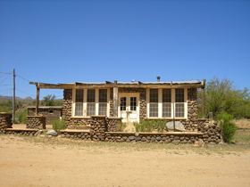
Bumble Bee is a ghost town in the Bradshaw Mountains of Yavapai County, Arizona, United States, named for nearby Bumble Bee Creek.
Contents
Map of Bumble Bee, Arizona 85324, USA
Development
Established in 1863, Bumble Bee served as a stagecoach stop and an outpost for the U.S. Cavalry, with a post office established in 1879. The creek, and by extension the town, were so named because early travelers in the area claimed that the Indians there were as "thick as bumblebees.”
Ghost town status
With the demise of the stagecoach and the mining in the surrounding area, the site eventually faded away. An attempt by Jeff Martin to make the town a tourist attraction during the mid-1930s resulted in the construction of the current buildings. In 1960, retired magazine publisher Charles A. Penn purchased the site and tried once again to establish a tourist attraction and museum. Penn died before his plans came to fruition and the property reverted to private ownership. Many of the faux historic buildings have since been torn down and smaller homes have been built in their place.
Bumble Bee is located 55 miles north of Phoenix, Arizona just off I-17 at Exit #248.