
OS grid reference TQ342994 | London borough Enfield Sovereign state United Kingdom | |
 | ||
Similar Bush Hill Park, Enfield Lock railway st, Crews Hill railway station, Enfield Island Village, Brimsdown railway station | ||
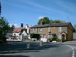
Bulls Cross is a hamlet located in the London Borough of Enfield, north London, and is part of London's Metropolitan Green Belt. It is located west of the A10 Great Cambridge Road and south from the M25 motorway. Crews Hill is located to the west, Bury Green (near Cheshunt) to the north, and Bullsmoor to the east.
Contents
- Map of Bulls Cross Enfield UK
- Etymology
- Tottenham Hotspur
- Geography
- Demography
- Places of interest
- Notable people
- References
Map of Bulls Cross, Enfield, UK
Etymology
Bulls Cross is recorded as Bedelscrosse in 1465. Recorded thus in c.1580 and on the Ordnance Survey map of 1822. The hamlet was also recorded in 1540 as Bullyscrosse meaning 'crossroads associated with the family called Bolle or Bull (who are mentioned in legal documents from the 13th century).
Tottenham Hotspur
In 2009 football club Tottenham Hotspur announced plans for a training centre to be built in the area. It was opened in September 2012.
Geography
Bulls Cross is located in the north of the borough. It is bordered by Bullsmoor Lane and Whitewebbs Lane to the north. Forty Hall to the south. and the New River to the east and Whitewebbs Park to the west.
Demography
Bulls Cross is part of the large Chase ward, which also covers Botany Bay, Clay Hill and Crews Hill. The 2011 census showed that 77% of the ward's population was white (64% British, 11% Other, 2% Irish). 5% was Black African and 3% Black Caribbean.