
OS grid reference TQ297992 Sovereign state United Kingdom Dialling code 020 | London borough Enfield Post town ENFIELD | |
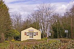 | ||
Botany Bay is a hamlet on the northern outskirts of the London Borough of Enfield. It has a population close to 200. The hamlet is centred at The Ridgeway - the road that links Enfield to Potters Bar and the M25 motorway. Enfield Chase lies to the south and west. It is about a mile from the railway station at Crews Hill.
Contents
It came into being when the Chase was enclosed in 1777 and was recorded as Botany Bay on C.G. Greenwood's map of 1819. Its remoteness from other settlements probably explains its name, as a facetious reference to Botany Bay in Australia. As there are places called Botany Bay dotted all over England, an alternative explanation is that these were originally staging points for convicts destined for transportation.
Amenities
The village has a public house, a farm with a well stocked shop and the 117 year Botany Bay Cricket Club which is housed in East Lodge Lane and shares its facilities with Botany Bay Petanque Club, Cuffley Rugby Club and is the home of the very successful Bay Jazz Club, Googlies Jazz Supper Club and Bigboppas Rock n Roll Club.
Demography
Botany Bay is part of the large Chase ward, which also covers Crews Hill, Clay Hill and Bulls Cross. The 2011 census showed that 77% of the ward's population was white (64% British, 11% Other, 2% Irish). 5% was Black African and 3% Black Caribbean.