
Founded 5 December 1866 | Congressional district 2nd Area 1,619 km² Population 10,639 (2013) | |
 | ||
Website www.bullockcountyal.com Rivers Pea River, Bughall Creek, Dry Creek, Johnsons Creek | ||
Help bullock county alabama traffic speeding ticket lawyer best bullock county al traffic attorney
Bullock County is a county of the U.S. state of Alabama. As of the 2010 census the population was 10,914. In 1867, Union Springs was chosen as the county seat. Its name is in honor of Colonel Edward C. Bullock of Barbour County.
Contents
- Help bullock county alabama traffic speeding ticket lawyer best bullock county al traffic attorney
- Map of Bullock County AL USA
- Bullock county alabama reckless driving attorney lawyer for bullock county al reckless driving
- History
- Geography
- Adjacent counties
- Demographics
- Government and infrastructure
- Major highways
- Airport
- City
- Town
- Census designated place
- Other unincorporated communities
- Ghost town
- Places of interest
- References
Map of Bullock County, AL, USA
A National Center for Education Statistics report released in January 2009 showed that Bullock County had the highest illiteracy rate in Alabama at 34 percent.
Bullock county alabama reckless driving attorney lawyer for bullock county al reckless driving
History
Bullock County was established on December 5, 1866. The boundaries were changed in February 1867.
Geography
According to the U.S. Census Bureau, the county has a total area of 625 square miles (1,620 km2), of which 623 square miles (1,610 km2) is land and 2.3 square miles (6.0 km2) (0.4%) is water. The county is in the southeastern section of the state, in the prairie region. The Chunnennuggee Ridge runs through the center of the county.
Adjacent counties
Demographics
As of the 2010 United States Census, there were 10,914 people residing in the county. 70.2% were Black or African American, 23.0% White, 0.4% Pacific Islander, 0.2% Native American, 0.2% Asian, 5.2% of some other race and 0.8% of two or more races. 7.1% were Hispanic or Latino (of any race).
As of the census of 2000, there were 11,714 people, 3,986 households, and 2,730 families residing in the county. The population density was 19 people per square mile (7/km2). There were 4,727 housing units at an average density of 8 per square mile (3/km2). The racial makeup of the county was 73.11% Black or African American, 25.25% White, 0.38% Native American, 0.18% Asian, 0.02% Pacific Islander, 0.37% from other races, and 0.70% from two or more races. 2.75% of the population were Hispanic or Latino of any race.
There were 3,986 households out of which 33.50% had children under the age of 18 living with them, 35.50% were married couples living together, 28.20% had a female householder with no husband present, and 31.50% were non-families. 28.90% of all households were made up of individuals and 12.30% had someone living alone who was 65 years of age or older. The average household size was 2.56 and the average family size was 3.13.
In the county, the population was spread out with 26.10% under the age of 18, 10.30% from 18 to 24, 29.30% from 25 to 44, 21.20% from 45 to 64, and 13.20% who were 65 years of age or older. The median age was 35 years. For every 100 females there were 110.20 males. For every 100 females age 18 and over, there were 113.40 males.
The median income for a household in the county was $20,605, and the median income for a family was $23,990. Males had a median income of $22,560 versus $19,069 for females. The per capita income for the county was $10,163. About 29.80% of families and 33.50% of the population were below the poverty line, including 44.70% of those under age 18 and 29.10% of those age 65 or over.
Government and infrastructure
Alabama Department of Corrections operates the Bullock Correctional Facility in an unincorporated area in the county.
Major highways
Airport
Franklin Field is a county-owned public-use airport located five nautical miles (9 km) west of the central business district of Union Springs, Alabama.
City
Town
Census-designated place
Other unincorporated communities
Ghost town
Places of interest
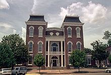
Bullock County is home to several historic homes including the McCaslan-Garner House and Bonus-Foster-Chapman House.