
Official name Buchanan Dam Opening date 1937 Elevation 318 m Population 1,688 (2000) | Construction began 1931 Zip code 78609 Area code Area code 512 | |
 | ||
Area 52.06 km² (19.68 km² Land / 32.37 km² Water) | ||
206 forest dr buchanan dam tx 78609 hd
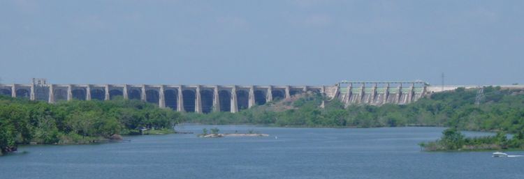
The Buchanan Dam (/ˈbʌkænən/) is a multiple arch dam located on the Colorado River of Texas. The dam forms Lake Buchanan and was the first dam to be completed in the chain of Texas Highland Lakes. The dam is used for generating hydroelectric power and for flood control and is located about 12 miles (19 km) west of Burnet, Texas.
Contents
- 206 forest dr buchanan dam tx 78609 hd
- Map of Buchanan Dam TX USA
- Willow point resort buchanan dam texas resort reviews
- HistoryEdit
- References
Map of Buchanan Dam, TX, USA
Willow point resort buchanan dam texas resort reviews
HistoryEdit
Construction of the then-named George W. Hamilton Dam was started in 1931 by a company controlled by Samuel Insull, but soon ended with the dam less than half completed when his highly leveraged public utility holding company collapsed during the Great Depression. In 1934, the Texas legislature authorized the formation of the Lower Colorado River Authority to complete the Hamilton dam. Following completion in 1937, the dam was renamed for U.S. Representative James P. Buchanan, who was involved obtaining federal funding the project from the Public Works Administration.
Construction of the dam required the relocation of the town of Bluffton, Texas. Relocation began in 1931 and was complete by 1939. A 2011 drought re-exposed the old Bluffton townsite.
Following a flood along the river in 1938, in which the dam was required to pass through all of the flow of water, there was criticism of the dam project as failing to meet its promise of preventing downstream floods. However, at the time it was pointed out that the Buchanan Dam was just the first in a series of four flood control dams, and that prevention of flooding would not be possible until they were finished.