
Area 6.7 km² | Canton Anzin Population (2009) 12,238 Local time Saturday 10:53 PM | |
 | ||
Weather 7°C, Wind S at 16 km/h, 87% Humidity | ||
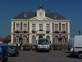
Bruay-sur-l'Escaut is a commune in the Nord department in northern France.
Contents
- Map of Bruay sur lEscaut France
- Geography
- Name of the commune
- Quarters
- Economy
- The mine of Thiers
- References
Map of Bruay-sur-l'Escaut, France
Geography
Bruay-sur-l'Escaut is 6 km north of Valenciennes on the left bank of the river Scheldt (French: Escaut): Bruay-sur-l'Escaut = Bruay on the Scheldt. It is 12 km from the Belgian border at Quiévrain.
Name of the commune
Named Bruail, Brueil, Bruel, Bruech in the Middle Ages and Bruay afterwards. In 1902 the name was changed to Bruay-sur-l'Escaut in order to avoid confusion with Bruay-la-Buissière in Pas-de-Calais.
Quarters
Economy
At 19th century there are 1300 inhabitants in Bruay, they worked in foundries and glasswares. In Starting from 1856, the inhabitants exploit the subterranean coal veins with a coalmine sunk by the Coalmines Compagny of Anzin ( in French : Compagnie des mines d'Anzin). Afterwards, some houses built and alien labour forces from Belgium recruited, the population of Bruay open out to 6000 inhabitants, some breweries and ironmongeries created, today disappeared.
The mine of Thiers
In 1728, the industries was greedies in combustibles, used up all forest wood around Bruay. Some drillings to find a coal veins has been attempted. The coalmine Lagrange, with low firedamp and a shaft with a depth of 139 metres, created in 1858. Some quicksands and water who invaded the building site ( 45 cubic metres per second), retarded the workers pending the coalmine construction. The name of the coalmine, Lagrange, descend of the baron Lagrange 's name, who was la Compagnie des mines d'Anzin manager. Starting from 1871 to 1873 the compagny created coalmine housses city around the coalmine (coron in French) to loge the coalmine labour workers. On October 10, 1918 the German soldiers dynamited the coal mine, the water invaded the galleries and the production has been stopped. The exploitation will go back to work in 1919. At this date, a coke firme and generating station created. The coalmine has been closed in 1954. The slag heap, rich in schiste, has been used for the construction of the A2 motorway ( autoroute A2 in French) in 1970 and the easel has been disassembled.