
Country United States Time zone EST (UTC-5) Zip code 46112 Local time Saturday 4:15 PM | Elevation 879 ft (268 m) Area code(s) 317 Population 23,160 (2013) | |
 | ||
Weather 8°C, Wind E at 21 km/h, 42% Humidity University PJ's College of Cosmetology | ||
657 westport drive brownsburg indiana 46112
Brownsburg is a town in Hendricks County, Indiana, United States. The population was 21,285 at the 2010 Census, an increase from 14,520 in 2000.
Contents
- 657 westport drive brownsburg indiana 46112
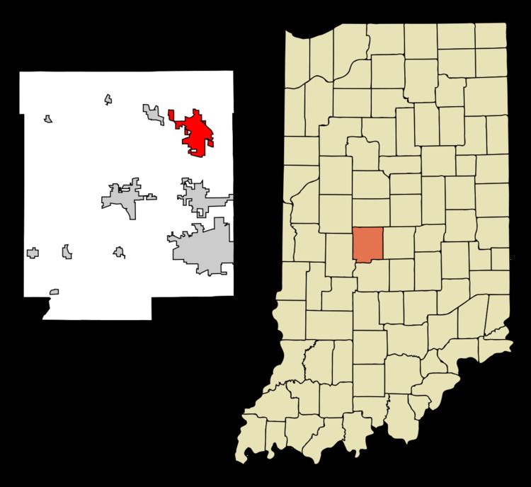
- Map of Brownsburg IN 46112 USA
- Holiday inn express indianapolis brownsburg i 74 w brownsburg indiana
- Geography
- 2010 census
- 2000 census
- History
- Public safety
- Public schools
- High schools
- Middle schools
- Elementary schools
- Private schools
- Notable people
- References
Map of Brownsburg, IN 46112, USA
In 2009, CNN Money Magazine ranked Brownsburg as the #1 place to live in Indiana, and #33 in the nation. The magazine cited Brownsburg's low crime, strong economy and excellent schools as factors for placing Brownsburg at the top.
Holiday inn express indianapolis brownsburg i 74 w brownsburg indiana
Geography
Brownsburg is located at 39°50′31″N 86°23′44″W (39.842032, -86.395641).
According to the 2010 census, Brownsburg has a total area of 11.16 square miles (28.90 km2), of which 11.08 square miles (28.70 km2) (or 99.28%) is land and 0.08 square miles (0.21 km2) (or 0.72%) is water. Interstate 74, running from Davenport, Iowa to Cincinnati, Ohio, crosses the northern part of Brownsburg before entering Indianapolis. Interstate 65 passes approximately 2 miles (3.2 km) northeast of the community and Interstate 70 about 10 miles (16 km) south. State Road 267 (Green Street) runs north and south through the middle of Brownsburg and serves as one of the town's main thoroughfares. US 136 (or Main Street) runs east and west along the southern half of the town.
2010 census
As of the census of 2010, there were 21,285 people, 7,948 households, and 5,816 families residing in the town. The population density was 1,921.0 inhabitants per square mile (741.7/km2). There were 8,376 housing units at an average density of 756.0 per square mile (291.9/km2). The racial makeup of the town was 93.4% White, 2.2% African American, 0.1% Native American, 1.6% Asian, 0.1% Pacific Islander, 1.2% from other races, and 1.4% from two or more races. Hispanic or Latino of any race were 3.0% of the population.
There were 7,948 households of which 40.9% had children under the age of 18 living with them, 58.7% were married couples living together, 10.5% had a female householder with no husband present, 4.0% had a male householder with no wife present, and 26.8% were non-families. 22.4% of all households were made up of individuals and 8.5% had someone living alone who was 65 years of age or older. The average household size was 2.64 and the average family size was 3.11.
The median age in the town was 36 years. 28.4% of residents were under the age of 18; 6.8% were between the ages of 18 and 24; 28.8% were from 25 to 44; 24.1% were from 45 to 64; and 12% were 65 years of age or older. The gender makeup of the town was 48.0% male and 52.0% female.
2000 census
As of the census of 2000, there were 14,520 people, and 5,366 households residing in the town. The population density was 1,983.5 people per square mile (765.9/km²). There were 5,574 housing units at an average density of 761.4 per square mile (294.0/km²). The racial makeup of the town was 97.44% White, 0.32% African American, 0.17% Native American, 0.78% Asian, 0.08% Pacific Islander, 0.35% from other races, and 0.86% from two or more races. Hispanic or Latino of any race were 1.18% of the population. There were 5,366 households out of which 41.8% had children under the age of 18 living with them, 64.0% were married couples living together, 8.6% had a female householder with no husband present, and 24.6% were non-families. 20.8% of all households were made up of individuals and 8.2% had someone living alone who was 65 years of age or older. The average household size was 2.65 and the average family size was 3.10.
In the town, the population was spread out with 29.2% under the age of 18, 6.8% from 18 to 24, 34.5% from 25 to 44, 17.9% from 45 to 64, and 11.7% who were 65 years of age or older. The median age was 33 years. For every 100 females there were 92.7 males. For every 100 females age 18 and over, there were 89.0 males.
The median income for a household in the town was $63,629, and the median income for a family was $74,245. Males had a median income of $56,240 versus $38,685 for females. The per capita income for the town was $33,196. About 1.5% of families and 2.3% of the population were below the poverty line, including 1.3% of those under age 18 and 4.4% of those age 65 or over.
History
Brownsburg's first settler was James B. Brown, a Kentucky native, who settled in Brown Township in 1824. At the time the area was dense and unbroken wilderness with only hunters and trappers in the area. Delaware Indians lived in what is now called Lincoln Township, along White Lick Creek, which was then called “Wa-pe-ke-way” or “White Salt”.
In 1828, the first log school house was built in Brown Township. One room brick schools were built every four miles, and everyone in the family except the mothers went to school when it was not crop season. The age range in the classroom was from six years to forty-three years. Brown Township was divided in 1863, becoming Brown Township to the North, named after its first resident. Lincoln Township was created to the South, being named after President Abraham Lincoln as a sign of support during the American Civil War. A stagecoach line was established along a road built in 1820 connecting all of the small outlying communities with Indianapolis.
Brownsburg was originally called Harrisburg, and under the latter name was laid out in 1835 by William Harris. The first post office in town was established as Brownsburgh in 1836. The first church building to be erected in Brownsburg was a log structure built in 1840. From the 1840s to the 1870s, the town almost tripled in size, from its original six acres to more than sixteen acres. 1848 brought the area’s first election with a total of ten male votes cast.
In 1869, the Big Four Railroad opened service to Brownsburg. By 1910, the Interurban was making daily trips between Indianapolis and Crawfordsville with scheduled hourly stops in Brownsburg.
In 1917, Superintendent of Schools Sylvester Moore and his wife were instrumental in forming Brownsburg’s first public library, funded by local gifts as well as a $12,500 gift from Carnegie Corporation. This building served as the Brownsburg Police Department headquarters for several years and is currently empty. The first two-story schoolhouse was built in 1917 on College Avenue. Later a gym was added to the site and was one of gymnasiums used for the filming of the movie Hoosiers. The late 1950s saw the first high school erection. It was during this time the first shopping area was established on the East edge of the Town.
Public safety
Brownsburg, along with Brown and Lincoln townships are served by the Brownsburg Fire Territory (BFT). BFT is responsible for 52 square miles. Currently Brownsburg Fire Territory employs 87 firefighters, civilian medics, and administrative staff to serve the community. The incorporated Town of Brownsburg is served by the Brownsburg Police Department (BPD). Within the BPD there are 7 divisions:
The townships of Brown and Lincoln are served by the Hendricks County Sheriff's office, though BPD often responds first.
Public schools
Brownsburg Community School Corporation maintains all public schools in Brownsburg. All public schools are fully accredited. Also in the past year (2013-2014) All Brownsburg Schools earned an A for ISTEP Testing
High schools
https://web.archive.org/web/20100417160930/http://www.brownsburg.k12.in.us:80/harris/