
Elevation 1,444 m | ||
 | ||
Similar Finger Mountain, E L Patton Yukon River Brid, Arctic National Wildlife R, Yukon River, Endicott Mountains | ||
Bears top gear trucks oh my dalton highway to atigun pass alaska on mmusa
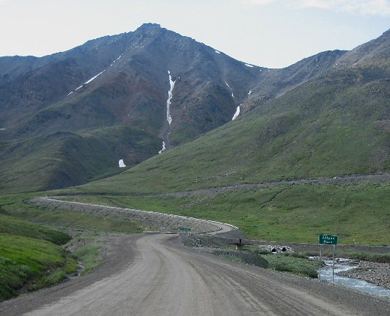
Atigun Pass (/ˈætɪɡən/ AT-i-gən), elevation 4,739 feet (1,444 m), is a high mountain pass across the Brooks Range in Alaska, located at the head of the Dietrich River. It is where the Dalton Highway crosses the Continental Divide (at mile marker 244), and is the highest pass in Alaska that is maintained throughout the year. Atigun is the only pass in the Brooks Range that is crossed by a road. The pass has been responsible for taking many drivers off the road and is also home to avalanches during the winter.
Contents
- Bears top gear trucks oh my dalton highway to atigun pass alaska on mmusa
- Map of Atigun Pass Alaska USA
- References
Map of Atigun Pass, Alaska, USA
Atigun is known among bush pilots for the difficulty of crossing the pass with small planes; Anaktuvuk Pass is favored as the safer flying route..
The pass is often shown on the third and fourth seasons of the History Channel reality series Ice Road Truckers, which focuses on the challenges of driving on the Dalton Highway.