
Length 0.8 km (0.5 mi) Elevation 240 m | Highest elevation 240 m (790 ft) Island group South Shetland Islands | |
 | ||
Population Uninhabited (although there are some weather stations) Similar Penguin Island, Deception Island, Seal Nunataks, Toney Mountain, Leskov Island | ||
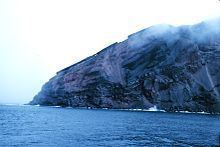
Bridgeman Island or Bridgemans's Island or Bridgman Island or Helena Island is one of the South Shetland Islands. It is an almost circular, volcanic island marked by steep sides, 0.8 kilometres (0.5 mi) long and 240 m (787 ft) high, lying 37 kilometres (23 mi) east of King George Island (South Shetland Islands). Bridgeman Island is located at 62°04′S 56°44′W and has an elevation of 240 m (787 ft). Bridgeman Island is an established name dating back to about 1820. Bridgeman Island is the remnants of a much larger volcanic edifice that is now largely submerged. The eroded volcano does not display youthful volcanic features. Several reports of 19th century fumarolic activity may instead refer to the much younger Penguin Island.
Map of Bridgeman Island, Antarctica
References
Bridgeman Island (South Shetland Islands) Wikipedia(Text) CC BY-SA