
Last eruption 1961 | Elevation 855 m Prominence 101 m | |
 | ||
Similar Bláhnjúkur, Eldgjá, Askja, Kerlingarfjöll, Torfajökull | ||
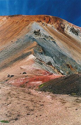
Brennisteinsalda view from the top landmannalaugar south iceland
The Brennisteinsalda is a volcano in the south of Iceland. Its height is about 855 m. It is situated near Landmannalaugar and not far from Hekla.
Contents
- Brennisteinsalda view from the top landmannalaugar south iceland
- Map of Brennisteinsalda Iceland
- Hiking landmannalaugar brennisteinsalda
- References
Map of Brennisteinsalda, Iceland
The name means in English: sulphur wave. It comes from the sulphur spots which have coloured its sides. But there are other colours, too: green from mosses, black and blue from lava and ashes, red from iron in the earth. It could very well be the most colourful mountain of Iceland and so its picture is often found in books and calendars.
The mountain is still visibly an active volcano with hot sulphur springs and vapour at its sides. The hiking trail Laugavegur passes by. In front of it there is an obsidian lava field.
Hiking landmannalaugar brennisteinsalda
References
Brennisteinsalda Wikipedia(Text) CC BY-SA