
Prominence 750 ft (229 m) | Topo map USGS Boundary Cone Elevation 1,046 m | |
 | ||
People also search for Black Mesa (Warm Springs, Arizona), Aubrey Peak, Mount Tipton, Spirit Mountain | ||
Part 2 rescue mission boundary cone mtn
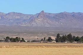
Boundary Cone is a geologic promontory located in the western foothills of the Black Mountains in Mohave County, Arizona. The peak is to the east of the Mohave Valley, northeast of Needles, California, and southeast of Bullhead City. The peak is about 4 miles (6 km) southwest of the mountain community of Oatman and 12 miles (19 km) east of the Colorado River.
Contents
- Part 2 rescue mission boundary cone mtn
- Map of Boundary Cone Arizona 86413 USA
- 3110 boundary cone in mohave valley az mohave county commercial real estate for sale
- HistoryEdit
- References
Map of Boundary Cone, Arizona 86413, USA
3110 boundary cone in mohave valley az mohave county commercial real estate for sale
HistoryEdit
Several Indian tribes attach religious and cultural significance to Boundary Cone as well as much of the surrounding landscape. In March 2006, the Bureau of Land Management determined and the Arizona State Historic Preservation Office concurred that Boundary Cone is eligible for inclusion on the National Register of Historic Places as a property of traditional, religious, and cultural importance to several Indian tribes.
Boundary Cone was a prominent landmark for early travelers in this region.