
 | ||
The borders of the oceans are the limits of the Earth's oceanic waters. The definition and number of oceans can vary depending on the adopted criteria.
Contents
Overview
Though generally described as several separate oceans, the world's oceanic waters constitute one global, interconnected body of salt water sometimes referred to as the World Ocean or global ocean. This concept of a continuous body of water with relatively free interchange among its parts is of fundamental importance to oceanography.
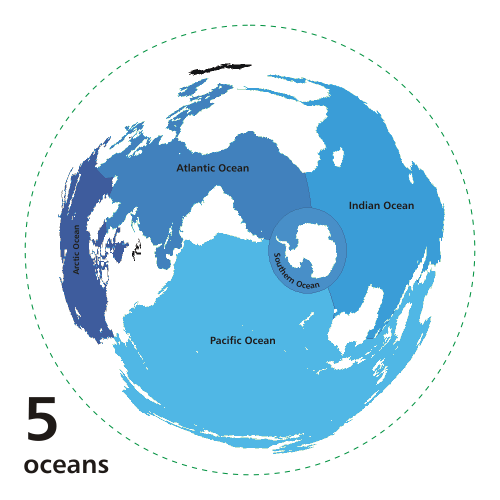
The major oceanic divisions are defined in part by the continents, various archipelagos, and other criteria. The principal divisions (in descending order of area) are the: Pacific Ocean, Atlantic Ocean, Indian Ocean, Arctic Ocean, and Southern (Antarctic) Ocean. Smaller regions of the oceans are called seas, gulfs, bays, straits, and other names.
Geologically, an ocean is an area of oceanic crust covered by water. Oceanic crust is the thin layer of solidified volcanic basalt that covers the Earth's mantle. Continental crust is thicker but less dense. From this perspective, the Earth has three oceans: the World Ocean, the Caspian Sea, and Black Sea. The latter two were formed by the collision of Cimmeria with Laurasia. The Mediterranean Sea is at times a discrete ocean, because tectonic plate movement has repeatedly broken its connection to the World Ocean through the Strait of Gibraltar. The Black Sea is connected to the Mediterranean through the Bosporus, but the Bosporus is a natural canal cut through continental rock some 7,000 years ago, rather than a piece of oceanic sea floor like the Strait of Gibraltar.
Despite their names, some smaller landlocked "seas" are not connected with the World Ocean, such as the Caspian Sea and numerous salt lakes such as the Aral Sea.
A complete hierarchy showing which seas belong to which oceans, according to the International Hydrographic Organization (IHO) and for the whole planet, is available at the European Marine Gazetteer website. See also the list of seas article for the seas included in each ocean area. Also note there are many varying definitions of the world's seas and no single authority.
Arctic Ocean
The Arctic Ocean covers much of the Arctic and washes upon northern North America and Eurasia and is sometimes considered a sea or estuary of the Atlantic.
The International Hydrographic Organization (IHO) defines the limits of the Arctic Ocean (excluding the seas it contains) as follows:
Note that these definitions exclude any marginal waterbodies that are separately defined by the IHO (such as the Kara Sea and East Siberian Sea), though these are usually considered to be part of the Arctic Ocean.
The CIA defines the limits of the Arctic Ocean differently, as depicted in the map comparing its definition to the IHO's definition.
Atlantic Ocean
The Atlantic Ocean separates the Americas from Eurasia and Africa. It may be further subdivided by the equator into northern and southern portions.
North Atlantic
The 3rd edition, currently in force, of the International Hydrographic Organization's (IHO) Limits of Oceans and Seas defines the limits of the North Atlantic Ocean (excluding the seas it contains) as follows:
South Atlantic
The 3rd edition (currently in force) of the International Hydrographic Organization's (IHO) Limits of Oceans and Seas defines the limits of the South Atlantic Ocean (excluding the seas it contains) as follows:
Note that these definitions exclude any marginal waterbodies that are separately defined by the IHO (such as the Bay of Biscay and Gulf of Guinea), though these are usually considered to be part of the Atlantic Ocean.
In its 2002 draft, the IHO redefined the Atlantic Ocean, moving its southern limit to 60°S, with the waters south of that line identified as the Southern Ocean. This new definition has not yet been ratified (and, in addition, a reservation was lodged in 2003 by Australia.) While the name "Southern Ocean" is frequently used, some geographic authorities such as the 10th edition of the World Atlas from the U.S. National Geographic Society generally show the Atlantic, Indian, and Pacific Oceans continuing to Antarctica. If and when adopted, the 2002 definition would be published in the 4th edition of Limits of Oceans and Seas, re-instituting the 2nd edition's "Southern Ocean", omitted from the 3rd edition.
Indian Ocean
The Indian Ocean washes upon southern Asia and separates Africa and Australia.
The 3rd edition, currently in force, of the International Hydrographic Organization's (IHO) Limits of Oceans and Seas defines the limits of the Indian Ocean (excluding the seas it contains) as follows:
Note that this definition excludes any marginal waterbodies that are separately defined by the IHO (such as the Bay of Bengal and Arabian Sea), though these are usually considered to be part of the Indian Ocean.
In its 2002 draft, the IHO redefined the Indian Ocean, moving its southern limit to 60°S, with the waters south of that line identified as the Southern Ocean. This new definition has not yet been ratified (and, in addition, a reservation was lodged in 2003 by Australia.) While the name "Southern Ocean" is frequently used, some geographic authorities such as the 10th edition of the World Atlas from the U.S. National Geographic Society generally show the Atlantic, Indian, and Pacific Oceans continuing to Antarctica. If and when adopted, the 2002 definition would be published in the 4th edition of Limits of Oceans and Seas, re-instituting the 2nd edition's "Southern Ocean", omitted from the 3rd edition.
The boundary of the Indian Ocean is a constitutional issue for Australia. The Imperial South Australia Colonisation Act, 1834, which established and defined the Colony of South Australia defined South Australia’s southern limit as being the “Southern Ocean.” This definition was carried through to Australian constitutional law upon the Federation of Australia in 1901.
Pacific Ocean
The Pacific is the ocean that separates Asia and Australia from the Americas. It may be further subdivided by the equator into northern and southern portions.
North Pacific
The 3rd edition, currently in force, of the International Hydrographic Organization's (IHO) Limits of Oceans and Seas defines the limits of the North Pacific Ocean (excluding the seas it contains) as follows:
South Pacific
The 3rd edition, currently in force, of the International Hydrographic Organization's (IHO) Limits of Oceans and Seas defines the limits of the South Pacific Ocean (excluding the seas it contains) as follows:
Note that these definitions exclude any marginal waterbodies that are separately defined by the IHO (such as the Gulf of Alaska and Coral Sea), though these are usually considered to be part of the Pacific Ocean.
In its 2002 draft, the IHO redefined the Pacific Ocean, moving its southern limit to 60°S, with the waters south of that line identified as the Southern Ocean. This new definition has not yet been ratified (and, in addition, a reservation was lodged in 2003 by Australia.) While the name "Southern Ocean" is frequently used, some geographic authorities such as the 10th edition of the World Atlas from the U.S. National Geographic Society generally show the Atlantic, Indian, and Pacific Oceans continuing to Antarctica. If and when adopted, the 2002 definition would be published in the 4th edition of Limits of Oceans and Seas, re-instituting the 2nd edition's "Southern Ocean", omitted from the 3rd edition.
Southern or Antarctic Ocean
The Southern Ocean contains the waters that surround Antarctica and sometimes is considered an extension of Pacific, Atlantic and Indian Oceans.
In 1928, the first edition of the International Hydrographic Organization's (IHO) Limits of Oceans and Seas publication included the Southern Ocean around Antarctica. The Southern Ocean was delineated by land-based limits - the continent of Antarctica to the south, and the continents of South America, Africa, and Australia plus Broughton Island, New Zealand in the north. The detailed land-limits used were Cape Horn in South America, Cape Agulhas in Africa, the southern coast of Australia from Cape Leeuwin, Western Australia, to South East Cape, Tasmania, via the western edge of the water body of Bass Strait, and then Broughton Island before returning to Cape Horn.
The northern limits of the Southern Ocean were moved southwards in the IHO's 1937 second edition of the Limits of Oceans and Seas. The Southern Ocean then extended from Antarctica northwards to latitude 40° south between Cape Agulhas in Africa (long. 20° east) and Cape Leeuwin in Western Australia (long. 115° east), and extended to latitude 55° south between Auckland Island of New Zealand (long. 165° or 166° east) and Cape Horn in South America (long. 67° west).
The Southern Ocean did not appear in the 1953 third edition because "...the northern limits ... are difficult to lay down owing to their seasonal change ... Hydrographic Offices who issue separate publications dealing with this area are therefore left to decide their own northern limits. (Great Britain uses the Latitude of 55° South)". Instead, in the IHO 1953 publication, the Atlantic, Indian and Pacific Oceans were extended southward, the Indian and Pacific Oceans (which had not previously touched pre 1953, as per the first and second editions) now abutted at the meridian of South East Cape, and the southern limits of the Great Australian Bight and the Tasman Sea were moved northwards.
The IHO readdressed the question of the Southern Ocean in a survey in 2000. Of its 68 member nations, 28 responded, and all responding members except Argentina agreed to redefine the ocean, reflecting the importance placed by oceanographers on ocean currents. The proposal for the name Southern Ocean won 18 votes, beating the alternative Antarctic Ocean. Half of the votes supported a definition of the ocean's northern limit at 60°S (with no land interruptions at this latitude), with the other 14 votes cast for other definitions, mostly 50°S, but a few for as far north as 35°S.
The 4th edition of Limits of Oceans and Seas has yet to be published due to 'areas of concern' by several countries relating to various naming issues around the world. The IHB circulated a new draft of the 4th edition of the publication in August 2002, however there were still various changes, 60 seas were added or renamed from the 3rd edition, and even the name of the publication was changed. A reservation had also been lodged by Australia regarding the Southern Ocean limits. Effectively, the 3rd edition (which did not delineate the Southern Ocean leaving delineation to local hydrographic offices) has yet to be superseded and IHO documents declare that it remains "currently in force."
Despite this, the 4th edition definition has de facto usage by many organisations, scientists and nations - even at times by IHO committees. Some nations' hydrographic offices have defined their own boundaries; the United Kingdom used the 55°S parallel for example.
Other sources, such as the National Geographic Society, show the Atlantic, Pacific and Indian Oceans as extending to Antarctica, although articles on the National Geographic web site have begun to reference the Southern Ocean.
In Australia, cartographic authorities defined the Southern Ocean as including the entire body of water between Antarctica and the south coasts of Australia and New Zealand. This delineation is basically the same as the original (first) edition of the IHO publication and effectively the same as the second edition. In the second edition, the Great Australian Bight was defined as the only geographical entity between the Australian coast and the Southern Ocean. Coastal maps of Tasmania and South Australia label the sea areas as Southern Ocean, while Cape Leeuwin in Western Australia is described as the point where the Indian and Southern Oceans meet.