
River mouth Lerma Santiago River Length 360 km Mouth Lerma River | ||
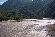 | ||
The Bolaños River is a river in Mexico flowing through the Sierra Madre Occidental, and a tributary of Rio Grande de Santiago. It has a length of 360 km and a watershed of about 10 000 square kilometers.
Contents
Map of Bola%C3%B1os River, Mexico
Geography
The river's origin is in the state of Zacatecas, about 60 km west of the city of Fresnillo, about 40 km south of Tropic of Cancer. Flowing south, it enters the state of Jalisco some 85 km later, eventually leading to the Lerma Santiago River, approximately 40 km northwest of the city of Tequila. The last 32 km of the river form the boundary between the states of Jalisco and Nayarit.
The principal municipalities transversed by the Bolaños River include:
References
Bolaños River Wikipedia(Text) CC BY-SA