
- elevation 305 m (1,001 ft) Basin area 18,000 km² | - elevation 111 m (364 ft) | |
 | ||
- left Genaren Creek, Sandy Creek, Bulbodney Creek - right Cookopie Creek, Burrill Creek, Gundong Creek, Tomingley Creek, Mulla Mulla Cowal, Moonagee Cowal, Gunningbar Creek, Nyangi Bogan Cowal, Bywash Billabong, Kellys Cowal - location Dry Bogan Weir, near Bourke | ||
Pig hunting bogan river nsw
Bogan River, a perennial river that is part of the Macquarie–Barwon catchment within the Murray–Darling basin, is located in the central west and Orana regions of New South Wales, Australia.
Contents
- Pig hunting bogan river nsw
- Map of Bogan River New South Wales Australia
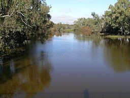
- Bogan river nyngan june 2016
- Geography
- Aboriginal history
- European history
- References
Map of Bogan River, New South Wales, Australia
From its origin near Parkes, the Bogan River flows for about 617 kilometres (383 mi) in length and flows into the Little Bogan River to form the Darling River, near Bourke.
The name Bogan is an Australian Aboriginal term meaning 'the birthplace of a notable headman of the local tribe'; and is also a Gaelic term meaning bog.
Bogan river nyngan june 2016
Geography
From the foothills of the Herveys Range, the Bogan River rises to the west of the headwaters of the Little River at Cooks Myalls, near Goonumbla, 19 kilometres (12 mi) north-west of Parkes. The river flows in a generally north-north-westerly direction past Tottenham, Peak Hill and through Nyngan. East of Bourke, the Bogan River joins with the Little Bogan River to form the Darling River. The Bogan River has over twenty tributaries. The main tributaries to the west are Bullock, Bulbodney, Pangee and Whitbarrow Creeks. The eastern catchment between the Bogan and Macquarie Rivers is ill-defined and has only one major tributary, Mulla Cowal. Other sources have claimed that Bugwah Cowal, and Burrill, Duck and Gunningbar Creeks are important tributaries.
Unlike the other main rivers of inland New South Wales, the Bogan does not rise in the well-watered highland areas, so its flow is low and erratic and not much use for irrigation.
Major weirs along the watercourse are at Muddal Weir, located west of Peak Hill; the Nyngan Weir, located north of Nyngan; and Gongolgon Weir, where the mean daily flow exceeds 700 megalitres (25×10^6 cu ft).
The Kamilaroi Highway crosses the Bogan River 43 kilometres (27 mi) east of Bourke.
Aboriginal history
A number of Aboriginal peoples lived in the lands surrounding the Bogan River for many thousands of years. In the area surrounding Peak Hill, the indigenous inhabitants of the area were the Wiradjuri clan. In the area surrounding Nyngan, the Ngiyambaa Aboriginal people were the principal custodians of the land.
European history
The river was crossed by John Oxley in 1817, but was named by Charles Sturt in his 1828-9 expedition as New Years Creek on 1 January 1829. It was also called the Bogan River prior to Major Sir Thomas Mitchell reaching here in 1835. On 17 April 1835 Richard Cunningham wandered away from the Mitchell party near the Bogan River and it is believed that he was killed here by Aborigines.
In April 1990, major flooding occurred along the river and in Nyngan, and despite a massive effort by local people to build levee walls using sandbags, 2,500 people had to be evacuated from the town. The floods caused A$50 million damage with the railway line so severely affected that rail services to Nyngan have since ceased, although freight services from Cobar are unaffected. Other significant flooding of the Bogan River occurred in 1928.