
Operator(s) MBTA Terminis Wonderland, Bowdoin | Daily ridership 67,519 (2016) Locale Boston | |
 | ||
Stations 13 in operation2 proposed | ||
The Blue Line is a rapid transit line in the Greater Boston metropolitan area, one of four subway lines operated by the Massachusetts Bay Transportation Authority (MBTA). It runs from Bowdoin station in downtown Boston under Boston Harbor to East Boston and Revere on the inner North Shore, where it terminates at Wonderland. The stop at Airport Station, with a free shuttle bus to Logan International Airport, is one of two rapid transit connections to the airport. The line was assigned the blue color in 1967 during a systemwide rebranding because it passes under Boston Harbor.
Contents
- Station renovations
- Extension to Lynn
- Red Line Blue Line Connector
- Accessibility
- Equipment
- Art and architecture
- References
The East Boston Tunnel was built as a streetcar tunnel in 1904; after an extension to Bowdoin in 1916, it was converted to heavy rail metro rolling stock in 1924. In 1952 and 1954 the line was extended along the former route of the Boston, Revere Beach and Lynn Railroad, in a project intended to reach Lynn but ultimately cut short to Wonderland. Further extensions to Lynn and Charles/MGH downtown are long-planned but not yet funded.
The East Boston Tunnel, when opened in 1904, was the first North American subway to run beneath a body of water, running under Boston Harbor, and the second underwater vehicular tunnel of significant length built in the United States. The tunnel was constructed using a modified version of the Greathead Shield; 2,700 feet (820 m) of the 1 mile (1.6 km) tunnel is actually under water. The excavation took two-and-a-half years, and cost $3 million and the lives of four workmen.
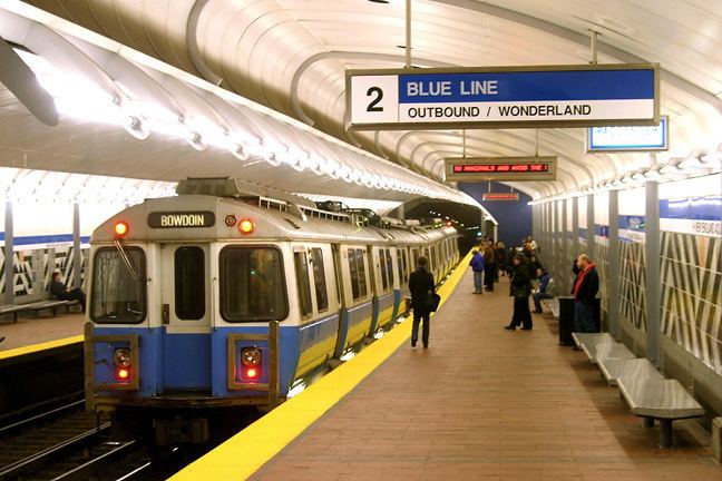
Initially designed to carry streetcars, the tunnel ran from Maverick Square in East Boston to downtown Boston's Court Street station, with an intermediate stop at Devonshire (now State). Court Street had pedestrian access to Scollay Square station (now Government Center) but transfers to the East Boston Tunnel required an additional fare of 1 cent. In 1906, Atlantic Station (now Aquarium) was opened, with a connection to the Atlantic Avenue Elevated. Court Street proved to be a problematic terminus as its single-track design limited frequent service. The Boston Elevated Railway (BERy) began an extension towards Beacon Hill in 1912. The downtown extension was opened to Bowdoin, with an intermediate stop at Scollay Under (now Government Center), on March 18, 1916. Immediately west of the new Bowdoin station platforms, a tight turnaround loop track underground allowed trains to quickly reverse direction for the return trip. An incline leading to a new portal at Joy Street was also installed at this time. The total cost of this extension was $2.3 million.
Increasing passenger loads soon required a further expansion of the carrying capacity of the harbor crossing. A new, four track station and two loops were constructed under Maverick Square in East Boston. The station was constructed while passenger service through the East Boston Tunnel was maintained. The new Maverick station would have the local East Boston streetcars enter the incline as always, but would stop inside the new station. All of the passengers would disembark the trolleys and cross the platform to the waiting rapid transit trains. A loop was provided west of the station for the trolleys to turn around and return to the outbound side of the station. The rapid transit trains would return to Boston via a loop on the eastern side of the station. A short extension of the tunnel beyond the east loop provided train storage and a couple of inspection pits for light maintenance.
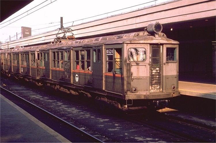
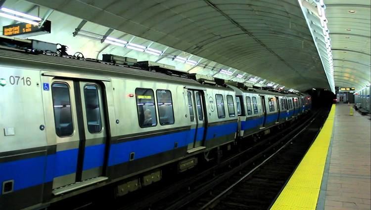
Over the weekend of April 18 to 21, 1924, the East Boston Tunnel was converted from streetcar use to high platform rapid transit, a tightly-staged changeover which had been in planning for three years, requiring 1500 men to complete. Rather than modify the narrow tunnel, the BERy elected to replace the streetcars with brand-new smaller-than-usual high-platform rapid transit cars which could operate in tight clearances—particularly around the tight loop at Bowdoin. Blue Line cars are thus 48.5 feet (14.8 m) long, substantially shorter than the 65-foot (20 m) Orange Line cars and the 69.5-foot (21.2 m) Red Line cars.
From 1952 to 1954, a surface-level extension was constructed along the recently-defunct Boston, Revere Beach and Lynn Railroad, from Maverick to the current terminus at Wonderland. The original trackage had been narrow gauge, but was converted to standard gauge for this Revere Extension of the subway. The first above-ground station on the new extension served Boston's Logan Airport, and was the first American urban transit connection to a commercial airfield. Beyond Maverick, the power feed was changed from third rail to overhead catenary (both at 600 V DC) to reduce the risk of winter ice buildup due to proximity to the ocean.
The line, officially known as the East Boston Tunnel & Revere Extension by the MTA since 1952, was redesignated "Blue" on August 26, 1965, as part of the new MBTA's color-based rebranding. The color blue represented water, as the line passes under Boston Harbor and travels near the coast for much of its length.
In the early part of the 20th century, the Blue Line was actually connected to the Red Line by a direct rail connection (though the color designations of the subway lines had yet to be assigned at that time). Railcars from the Blue Line could emerge from a ramp portal surfacing between Joy Street and Russell Street, just beyond Bowdoin station. The railcars would run on former streetcar track down Cambridge Street and then most of the distance to the western end of the Longfellow Bridge, connecting to the Red Line just east of its Cambridge Subway portal, near what is now Kendall/MIT station. Because the tracks were unpowered, individual cars had to be towed along the street at night. This connection was never used in passenger service, but was used to transport Blue Line cars to the Eliot Street Yard maintenance shops then located near Harvard Square station. When the Blue Line eventually got its own maintenance shops, the connection was removed and the ramp portal was permanently covered in 1952.
In 2012, there were plans to rebuild this historic Red/Blue Line connection, but in a more permanent manner. The new connection would be entirely underground, with no direct track connection—passengers would transfer at Charles/MGH inside a fare paid area. However, planning for the project was suspended because of financial difficulties.
Station renovations
The Blue Line Modernization Project, which began in the 1990s and is still under way, includes renovating stations to increase the length of trains from four to six cars, to make all stations wheelchair accessible, and to improve appearance. On June 25, 1994, the line was cut back to Orient Heights at all times to permit reconstruction of the outer stations. Beachmont and Wood Island were completely rebuilt, while Suffolk Downs, Revere Beach and Wonderland were renovated. A simultaneous $8 million noise reduction program added sound walls at Beachmont and Orient Heights, rubber mats under tracks, and soundproofing of nearby homes. The stations reopened on June 26, 1995.
Aquarium was closed from October 14, 2000 until October 29, 2001 for renovations, which were completed in 2004. A new Airport Station opened on June 3, 2004, replacing the previous station which was closed as part of Big Dig construction. An extension renovation of State, during which the station remained open, lasted from 2005 to 2011.
The first Blue Line six-car trains began service on September 15, 2008. Passengers can disembark from all six cars at the outbound platform of Bowdoin Station, but due to the shape of the platform (which is inside a balloon loop), passengers can only board four cars at the inbound side. The MBTA uses "POP buttons" on the outside of six-car trains to allow passengers to open only the doors they need to board. The station may eventually be closed or reconfigured as part of the Red Line Blue Line Connector project, as discussed below.
Renovations at Maverick were completed in 2009. Orient Heights station was closed for eight months in 2013 for a complete rebuild; its reopening in November 2013 left all Blue Line stations outside of downtown fully handicapped accessible and modernized. Government Center station closed from March 22, 2014 to March 21, 2016 for a complete renovation and accessibility modifications.
Extension to Lynn
There is a proposal to extend the Blue Line northward to Lynn, Massachusetts. The land to extend the line was purchased for the initial construction of the Revere Extension, but due to budgetary constraints Wonderland station was designated the northern terminus. Two potential extension routes have been identified. One proposed path would run through marshland alongside the existing Newburyport/Rockport commuter rail line, on rail lines formerly operated by the Boston and Maine Railroad. An alternative route would extend the line alongside Revere Beach Boulevard through Point of Pines and the Lynnway, along the remainder of the BRB&L right of way. Other alternatives include increased commuter rail or bus service, or connecting the Blue Line to a commuter rail stop near Wonderland via a short connector.
The Blue Line extension has been proposed in various forms for over 80 years. The 1926 Report on Improved Transportation Facilities and 1945–47 Coolidge Commission Report recommended that the East Boston Tunnel line, which had been converted to rapid transit from streetcars in 1924, be extended to Lynn via the Boston, Revere Beach & Lynn right-of-way. Ever since the 1954 Revere extension was cut short to Wonderland, a further extension to Lynn has been planned. Following on the 1926 and 1945-47 studies, the 1966 Program for Mass Transportation recommended that the Blue Line be extended to Lynn, while the 1969 Recommended Highway and Transit Plan proposed that the extension run as far as Salem. An extension was not present in the 1972 Final Report of the Boston Transportation Planning Review, but the 1974 Transportation Plan revived the project with possible termini of Lynn, Salem, or even Route 128 in Peabody. The 1978 Program for Mass Transportation report and 1983 Transportation Plan both continued support for an extension to Lynn. Despite the continued recommendations, however, other projects like extensions of the Red and Orange lines were given funding instead of the Blue Line.
In 2005, Lieutenant Governor Kerry Healy estimated construction would begin in 2017. Authorization to bond for planning money for the project was included in an April 2008 state bond bill, and $25 million in federal earmarks have been obtained. A 2004 state bond bill authorized $246.5 million on the condition of finding 50% non-state matching funds (which presumably would come from the federal government). The Draft Environmental Impact Report was expected to be complete by the end of 2008, but has been delayed as planners focus on meeting the legal deadline for the Green Line extension to Somerville and Medford.
Red Line-Blue Line Connector
The Green Line has been the most convenient way to transfer between the Blue Line and the Red Line, thus causing the short Green Line segment between Government Center station and nearby Park Street station to be especially congested during peak travel times, causing significant delays in the entire system. In the past, an underground pedestrian passage had been proposed, paralleling the Green Line tracks and connecting the two stations, but this idea was dropped in favor of a direct transfer connection between the Blue and Red Lines.
It also is possible to transfer between the Red and Blue Lines by traveling one stop on the Orange Line between State and Downtown Crossing stations, but this path involves navigating a longer and more convoluted path through stairs and passages of those stations. The Red and Blue Lines are the only pair of rapid transit lines in the MBTA system that lack a direct transfer connection. The idea of connecting them was studied in the Boston Transportation Planning Review in 1972.
As part of a lawsuit settlement relating to air quality mitigation for the Big Dig highway tunnel project, the Commonwealth of Massachusetts agreed to build a direct transfer connection between the Blue and Red Lines. This would be done by extending the Blue Line beyond Bowdoin station, continuing to run a further 1,500 feet (460 m) beneath Cambridge Street to Charles/MGH station on the Red Line. Unlike the historic Red/Blue Line connection described earlier, there would be no direct rail connection between lines at Charles/MGH station (the rail gauges are identical, but the Red and Blue Line railcars are otherwise dimensionally incompatible). However, passengers would be able to transfer between the Red and Blue Lines without needing to crowd onto the Green Line and many passengers from the North Shore of Boston would be able to reach the Massachusetts General Hospital area directly without further transfers. The addition of the connector is expected to add 12,000 daily boardings at Charles/MGH station, reducing vehicle miles traveled by 5,250 per day.
After failing to take any action for over a decade, and under threat of further lawsuits, the state finally agreed to start detailed engineering design for such an extension. Construction was expected to take six years, but a start date and funding scheme were never announced. The MBTA ultimately decided not to complete the design work necessary to build the Red/Blue Connector, as funding for constructing it was seen as an impossibility. The possibility of a public-private partnership (P3) to advance the project was studied in 2013.
North-South Rail Link
The North–South Rail Link is a proposed MBTA Commuter Rail tunnel which would link North and South Stations. The tunnel would consist of three stations, two underneath the existing terminals and a third underneath Aquarium. Should this link become a reality, it would be possible to transfer from any commuter rail line to the Blue Line or the Silver Line. From Aquarium, a rider could travel north to Airport within five minutes. MassPort is currently examining the possibly of a direct pedestrian connection the Airport station from terminal E.
Accessibility
From approximately 1998-2011, the MBTA made most Blue Line stations fully accessible as part of a larger effort to accommodate 6-car trains on the line. As of 2016, the only station in service on the Blue Line which is not fully accessible is Bowdoin.
Equipment
Like the MBTA Orange Line and Red Line, the Blue Line tracks are standard gauge heavy rail. The Green Line uses Light Rail (Streetcar) which can run in mixed traffic in city streets.
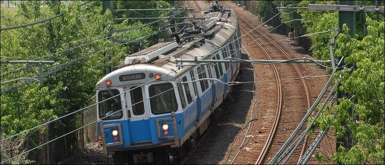
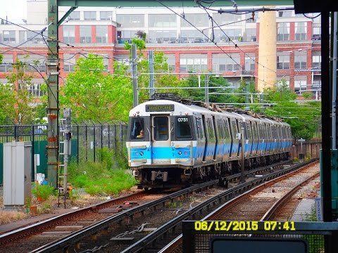
Blue Line cars are unique among rapid transit vehicles in Boston, in that they use both third rail power and pantograph current pickup from overhead catenary wires. Trains switch between the two modes at Airport station, near where the line transitions between running in a tunnel and running above ground. Previously, the switchover was made underground at Maverick station. The overhead pantograph was implemented to avoid third rail icing that frequently occurs in winter. Third rail power is used in the original Blue Line tunnels, which are smaller than most modern subway tunnels.
The Blue Line cars are also narrower and shorter than otherwise similar ones running on the Orange Line, due to the stations and tunnels on the former line having been originally designed to accommodate streetcars.
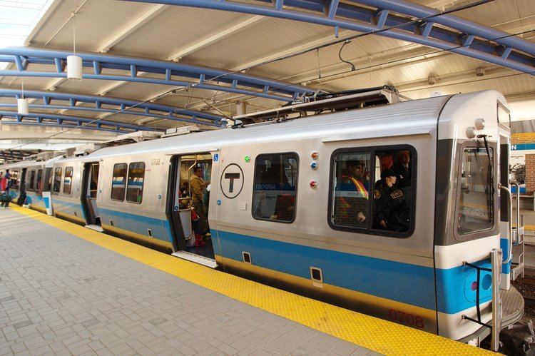
The Blue Line fleet consists mainly of 94 700-series cars (47 pairs) with stainless steel bodies from Siemens, with each car 48 feet (15 m) long and 9 feet 3 inches (2.82 m) wide, with two pairs of doors per side. The cars are of a similar design to those built for the Tren Urbano system in San Juan, Puerto Rico, also designed by Siemens. Originally scheduled to be delivered beginning in January, 2004, the development of the trains had been beset with problems, and the delivery was pushed back numerous times. The cars were eventually delivered beginning in January, 2007. The contract price of the cars is $174 million, with a total cost to the MBTA (including engineering and other related services) of $200 million.
Previously, all of the fleet consisted of the 0600 series, built 1978-1980 by Hawker Siddeley Canada Car and Foundry (now Bombardier Transportation) of Thunder Bay, Ontario, Canada. They were 48 feet 10 inches (14.88 m) long and 9 feet 3 inches (2.82 m) wide, with two pairs of doors on each side and a design maximum speed of 65 mph (105 km/h). The design was based on the PA3 model used by PATH in New Jersey. There were originally 70 Hawker cars, numbered 0600-0669.
By 2011, most of the 600-series cars were retired because of severe corrosion, mainly caused by the salty air that results from much of the line being very close to the ocean. Several 600-series cars were retained MBTA property but no longer usable. Parts of scrapped cars are used to maintain Orange Line 1200 series rolling stock, which were built at the same time by Hawker Siddeley and used many of the same components.
Around 2009, the Seashore Trolley Museum received retired Hawker set 622-623 for their collection.
Art and architecture
The MBTA maintains an online catalog of the over 90 artworks installed along its six major transit lines. Each downloadable guide is illustrated with full-color photographs, titles, artists, locations, and descriptions of individual artworks.