
Cause Under investigation Dates 16 Aug 2016 – 23 Aug 2016 | Burned area 149.7 km² | |
 | ||
Buildingsdestroyed 105 homes213 outbuildings Similar Soberanes Fire, Pilot Fire, Clayton Fire, Canyon Fire, Sand Fire | ||
Blue cut fire forces 82 000 evacuations in cajon pass
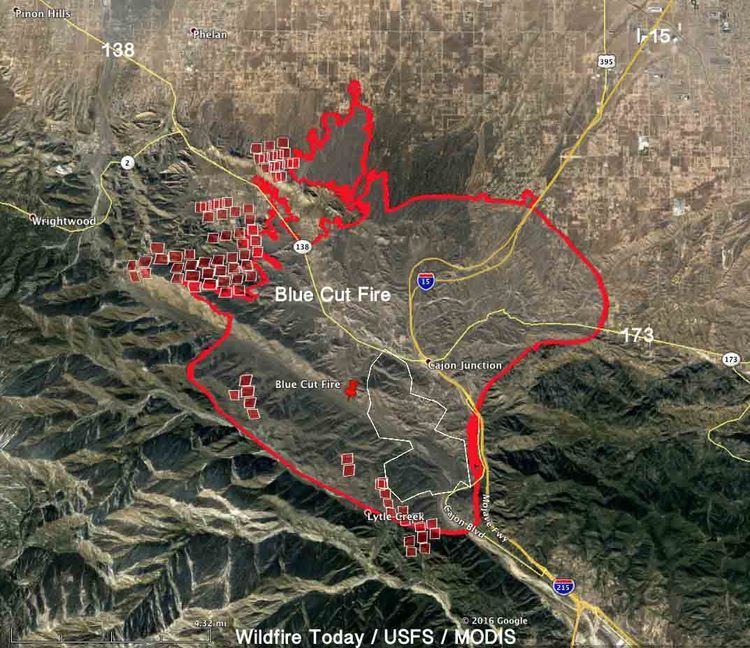
The Blue Cut Fire was a wildfire in the Cajon Pass, northeastern San Gabriel Mountains, and Mojave Desert in San Bernardino County, California. The fire, which began on the Blue Cut hiking trail, was first reported on August 16, 2016 at 10:36 a.m., just west of Interstate 15. A red flag warning was in effect in the area of the fire, with temperatures near 100 °F (38 °C) and winds gusting up to 30 miles per hour (48 km/h).
Contents
- Blue cut fire forces 82 000 evacuations in cajon pass
- Afternoon aerials blue cut fire in southern california
- Events
- Effects
- References
By August 18, the fire had burned 37,000 acres (57.8 sq mi; 149.7 km2) of land and destroyed 105 homes and 213 other structures.
Afternoon aerials blue cut fire in southern california
Events
Shortly after the fire broke out, evacuations began to be ordered for the nearby communities of West Cajon Valley, Lytle Creek, Lone Pine Canyon and Swarthout Canyon. By 3:00 p.m. on August 16, less than six hours after the fire started, it had spread westward to over 5,500 acres (2,200 ha), forcing additional mandatory evacuation orders for most of Oak Hills, Phelan and Summit Valley.
Two firefighters were injured and briefly hospitalized on the morning of August 17, 2016 after becoming trapped while protecting homes in Swarthout Canyon.
In a conference on August 17, the incident commander, battalion chief Michael Wakoski, stated that Cajon Pass acts as a natural wind tunnel, creating a funnel that can increase wind speeds by 20–30 miles per hour (32–48 km/h). These winds were causing the fire to spot upwards of a half mile (0.8 km) ahead of itself.
By Thursday, August 18, the fire had grown to over 31,600 acres (49.4 sq mi; 127.9 km2) and forced the evacuation of over 82,000 residents. The evacuations affected an estimated 34,500 residences.
On Monday, August 22, fire officials said they had the fire 89% contained. The damaged area had grown to 37,020 acres (57.8 sq mi; 149.8 km2).
Fire officials declared the devastating wildfire fully contained Tuesday, August 23. The fire destroyed an estimated 105 homes and 213 other structures in San Bernardino County and now ranks as the 20th most destructive wildfire in state history, said Daniel Berlant, a spokesman for the California Department of Forestry and Fire Protection.
Effects
Due to the rapid growth and spread of the fire, fire officials ordered mandatory evacuations for over 82,000 residents in surrounding communities, including Wrightwood. The Summit Inn, a historic U.S. Route 66 roadside diner built in 1952, was destroyed by the fire.
On Tuesday, August 16, 2016, CalTrans closed Interstate 15 through the Cajon Pass. This Interstate serves as the main route between Los Angeles and Las Vegas, Nevada.
Ten of the buildings belonging to the Thanksgiving Korean Church retreat in Phelan were destroyed by the fire. Another victim of the fire lost 135 of her livestock, and most of her property.