Time zone CET (UTC+1) Number of municipalities 29 | Population 61,407 (2012) | |
 | ||
Points of interest Silvretta Alps, Rätikon, Verwall Alps, Silvretta Montafon, Sonnenkopf Destinations | ||
The Bezirk Bludenz is an administrative district (Bezirk) in Vorarlberg, Austria.
Contents
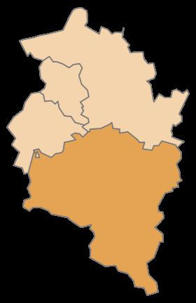
Map of Bludenz District, Austria
Area of the district is 1,287.63 km², population is 61,407 (January 1, 2012), and population density 48 persons per km². Administrative center of the district is Bludenz.
Administrative divisions
The district is divided into 29 municipalities, one of them is a town, and two of them are market towns.
Towns
- Bludenz (13,801)
Market towns
- Nenzing (5,976)
- Schruns (3,683)
Municipalities
- Bartholomäberg (2,281)
- Blons (324)
- Bludesch (2,220)
- Brand (666)
- Bürs (3,113)
- Bürserberg (528)
- Dalaas (1,512)
- Fontanella (433)
- Gaschurn (1,515)
- Innerbraz (933)
- Klösterle (690)
- Lech am Arlberg (1,636)
- Lorüns (281)
- Ludesch (3,375)
- Nüziders (4,880)
- Raggal (822)
- Sankt Anton im Montafon (751)
- Sankt Gallenkirch (2,190)
- Sankt Gerold (361)
- Silbertal (860)
- Sonntag (679)
- Stallehr (288)
- Thüringen (2,158)
- Thüringerberg (683)
- Tschagguns (2,169)
- Vandans (2,599)
(population numbers January 1, 2012)
References
Bludenz District Wikipedia(Text) CC BY-SA
