
Vehicle registration BZ Elevation 1,145 m Population 429 (1 Apr 2009) Postal code 6733 | Time zone CET (UTC+1) Website www.fontanella.at Area 31.23 km² Local time Tuesday 4:18 AM Area code 05554 | |
 | ||
Weather 0°C, Wind E at 3 km/h, 72% Humidity Points of interest Bregenz Forest, Skigebiet Damüls Mellau, Glatthorn | ||
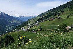
Geography
About 29.5% of the municipality is forested, and 52.1% is alpine.
Subdivisions
The municipality consists of the villages Fontanella, Garlitt, Mittelberg, Türtsch, Kirchberg, Seewald and Faschina.
Economy
There are 18 companies. 102 persons are employed. In the tourism year 2001/2002 there were a total of 70,365 nights.
History
Fontanella was founded by settlers from Valais in the 14th century. It was occupied by France from 1945 to 1955.
References
Fontanella, Austria Wikipedia(Text) CC BY-SA