
Country Canada Time zone EST (UTC-5) Area 1,162 km² Local time Friday 6:32 AM | Postal code FSA P0K Population 2,410 (2011) Area code Area codes 705 and 249 | |
 | ||
Website www.blackriver-matheson.com Weather -27°C, Wind W at 8 km/h, 79% Humidity | ||
Black River-Matheson is a township in the Cochrane District of the Canadian province of Ontario. The municipality is astride the Black River, for which it is partly named. The Matheson railway station was serviced by the Northlander until 2012.
Contents
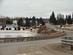
Map of Black River-Matheson, ON, Canada
Mining, forestry and farming are some of the principal industries in the area, augmented by outdoor tourism in the summer, such as fishing and hunting. There are three elementary schools within the municipality.
Communities
The communities in the township are Holtyre, Matheson, Ramore, Shillington, Val-Gagné and Wavell. The main community of Matheson is located at the intersection of highways 11 and 101.
History
Prospecting started in 1909. The Croesus Mine (1914-1918) became "one of the richest mines in Canada," according to Barnes. Gold was like "plums in pudding" and "one gold nugget was egg shaped, two inches long and one and a quarter across." A total of 16 companies operated in the Harker Holloway area from 1917 to 1925, including Harker Gold Mines. P.A. McDermott found a gold-bearing zone in 1922, which became American Barrick's Holt-McDermott Mine in 1988. Located in the Abitibi greenstone belt, the mine produced 60,000 ounces of gold in 1994.
The fire of 1916 left 243 dead.
Demographics
Population trend: