
Elevation 4,013 m | ||
 | ||
Passes Powder River Pass, Granite Pass Mountains Cloud Peak, Bomber Mountain, Black Tooth Mountain, Penrose Peak, Darton Peak Similar Cloud Peak, Wind River Range, Bomber Mountain, Black Tooth Mountain, Yellowstone Caldera | ||
Massive crack in earth mysteriously opens up in bighorn mountains wyoming
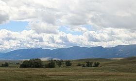
The Bighorn Mountains (Apsáalookěi: Basawaxaawúua or Iisaxpúatahchee Isawaxaawúua) are a mountain range in northern Wyoming and southern Montana in the United States, forming a northwest-trending spur from the Rocky Mountains extending approximately 200 miles (320 km) northward on the Great Plains. They are separated from the Absaroka Range, which lie on the main branch of the Rockies in western Wyoming, by the Bighorn Basin.
Contents
- Massive crack in earth mysteriously opens up in bighorn mountains wyoming
- Map of Bighorn Mountains Wyoming 82834 USA
- Driving in the bighorn mountains wyoming
- Geology
- Geography
- Recreation and human culture
- References
Map of Bighorn Mountains, Wyoming 82834, USA
Driving in the bighorn mountains wyoming
Geology
The Bighorns were uplifted during the Laramide orogeny beginning approximately 70 million years ago. They consist of over 9,000 feet (2,700 m) of sedimentary rock strata laid down before mountain-building began: the predominantly marine and near-shore sedimentary layers range from the Cambrian through the Lower Cretaceous, and are often rich in fossils. There is an unconformity where Silurian strata were exposed to erosion and are missing. Following the uplift, large volumes of sediments, rich in early Tertiary fossils, were deposited in the adjoining basins. Though many cirques, U-shaped valleys and glacial lakes can be found in the mountain range, the only remaining active glacier is the Cloud Peak Glacier, which is on the east slope of Cloud Peak.
Geography
The highest peaks within the Bighorns are located in Wyoming in the 1.12 million acre (4,500 km²) Bighorn National Forest. Two peaks rise to over 13,000 feet (3,960 m) Cloud Peak (13,175 ft, 4013 m) and Black Tooth Mountain (13,005 ft, 3964 m). There are a dozen more that rise to over 12,000 feet (3,650 m). From the east the mountains present a vertical relief of over 8,000 feet (2,450 m), rising abruptly from the plains. Overall, the Bighorns are more rounded than their sister mountain ranges to the west.
The Cloud Peak Wilderness is the centerpiece of a roadless block of land around 189,000 acres in size. The Wilderness is surrounded by unprotected acreage of U.S National Forest as well as Bureau of Land Management, state, and some private land. Most of the Cloud Peak Wilderness is above the tree line; the unprotected lands surrounding it are lower in elevation and covered in coniferous forests. Mule deer, elk, moose, black bear, and mountain lion are found throughout the area.
Two more large roadless areas remained in the Bighorns as of 1992. It is unknown whether these areas have since been reduced in size by road-building and other development. Both areas straddle the Montana-Wyoming state line, in the northern part of the range. One area, north of U.S. Route 14A and containing the headwaters of the Little Bighorn River, is 155,000 acres of National Forest land. This little-known region features subalpine terrain cut by steep canyons. Pronghorn inhabit the area, as it includes a portion of the Great Plains. What little human use it receives is from hunters and fishermen. The second roadless area is located mainly on the Crow Indian Reservation in Montana; its 144,000 acres also includes 34,000 acres of Devil's Canyon on the Bighorn N.F. in Wyoming. In this part of the range, semidesert prairie is cut by steep canyons leading to Yellowtail Reservoir, and high, Douglas-fir cloaked ridges top out at over 9,000'. Colorful rock formations are common. Rocky Mountain juniper and limber pine are scattered on lower elevations, and wildlife includes pronghorn, rattlesnake, golden eagle, ferruginous hawk, and mule deer. The Crow Indians manage a wild bison herd on this portion of the Bighorns. The Crow lands are a sacred area, and thus are off-limits to non-tribal members.
The three highways traversing the Bighorns are designated Scenic Byways by the US Forest Service and the State of Wyoming. These include U.S. Routes 14, 14A, and 16.
The range is the location of the headwaters of the Little Bighorn, Tongue, and Powder rivers.
Bighorn Canyon National Recreation Area consists of approximately 120,000 acres (490 km2) within the Bighorn Mountains. It includes Bighorn Lake, a reservoir damming the Bighorn River.
In 2015, a sudden, huge 'gash' was found in Wyoming's Big Horn Mountains. The Wyoming Geological Survey studied the area and determined that "The Crack" may be the result of an "apparent active landslide" in the southern end of the Big Horn Mountains.
Recreation and human culture
The Bighorns are a popular destination for hiking, backpacking, fly fishing, horse back riding and increasingly ATV riding and snowmobiling. Trails wind through most of the national forest. The Cloud Peak Wilderness has a network of hiking trails to remote areas and alpine lakes. Higher trails are often covered with snow except from July through August. After Labor Day, there is a good chance of high country snow storms at any time.
The Bighorns are home to one of the elite ultramarathons in the nation. The Bighorn Trail Run is held every June.
The Sioux, Crow, and Cheyenne Indians have long considered the Bighorns sacred mountains.