
Max. length 26 mi (42 km) Area 51.03 km² | Primary inflows Surface elevation 294 m Length 42 km | |
 | ||
Surface area 12,610 acres (5,100 ha) Cities Ortonville, Big Stone City, Browns Valley | ||
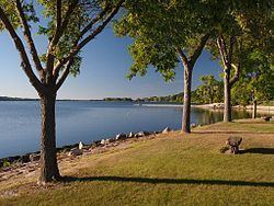
Big Stone Lake is a long, narrow freshwater lake and reservoir forming the border between western Minnesota and northeastern South Dakota in the United States. The lake covers 12,610 acres (5,100 ha) of surface area, stretching 26 miles (42 km) from end to end and averaging around 1 mile (1.6 km) wide, and at an elevation of 965 feet (294 m) is the lowest point in South Dakota. Big Stone Lake is the source of the Minnesota River, which flows 332 miles (534 km) to the Mississippi River.
Map of Big Stone Lake, United States
Flow from the lake to the Minnesota River is regulated by the Big Stone Lake Dam, built in 1937 and located at the southern end of the lake. Although modest, the dam controls a maximum capacity of 205,000 acre-feet. The dam is owned and operated by the state of Minnesota.
The lake is fed by the Little Minnesota River at its north end, which flows through the Traverse Gap. Big Stone was formed at the end of the last ice age when glacial Lake Agassiz drained through the gap into Glacial River Warren. The valley of that river now holds Big Stone Lake. Big Stone Lake is shown on the 1757 edition of Mitchell Map as "L. Tinton", referring to the Lakota people, also known as Tetonwan ("dwellers of the prairie"). Big Stone Lake was named for nearby rock outcroppings.
Two state parks are located at the lake: Big Stone Lake State Park in Minnesota and Hartford Beach State Park in South Dakota. The two parks provide picnic, boat launching, trail, and camping facilities. An educational center at the lake is part of the Minnesota state park. Several vacation resorts are located along the shores of Big Stone Lake as well. Visitors are attracted to the lake especially for its fishing: walleye, northern pike, and bluegills are all popular game fish with anglers, and the lake contains over 30 other species. There are 12 public accesses for fishing use. The lake is stocked once every two years with 7,000,000 walleye fry.
The communities of Ortonville, Minnesota, and Big Stone City, South Dakota, are located at the southern tip of the lake; Browns Valley, Minnesota, is located at the northern tip.