
Opening date 1964 Height 154 m (505 ft) Construction began 1958 | Status In use Opened 1964 | |
 | ||
Location Amphoe Sam Ngao, Tak Province Similar Sirikit Dam, Vajiralongkorn Dam, Khao Kho National Park, Wat Suwandararam, Srinagarind Dam | ||
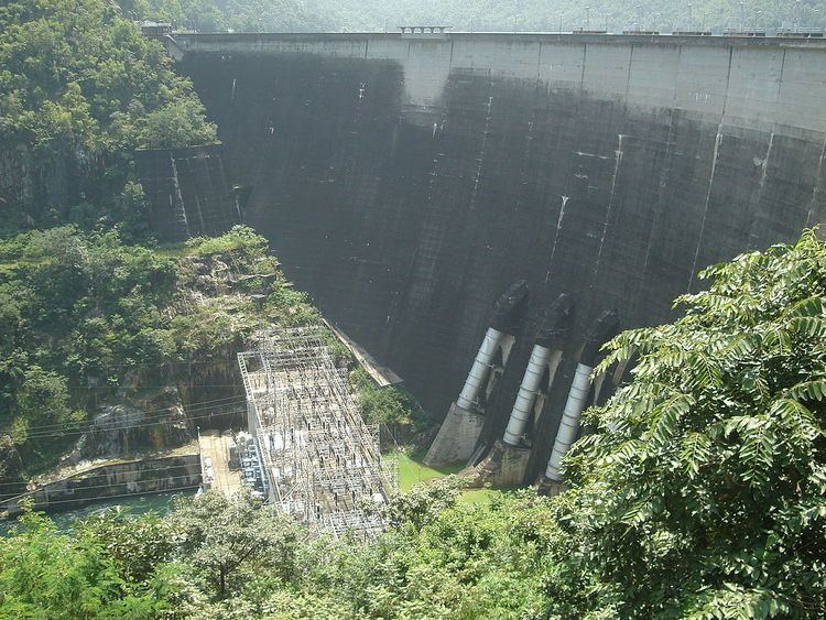
The Bhumibol Dam (formerly known as the Yanhi Dam) is a concrete arch dam on the Ping River, a tributary of the Chao Phraya River, in Amphoe Sam Ngao district of Tak Province, Thailand. It is about 480 km (298 mi) north of Bangkok and was built for the purposes of water storage, hydroelectric power production, flood control, fisheries and saltwater intrusion management. The dam was named after King Bhumibol Adulyadej and was Thailand's first multi-purpose project.
Contents
- Map of Bhumibol Dam Tambon Ban Na Amphoe Sam Ngao Chang Wat Tak 63130 Thailand
- Bhumibol dam
- BackgroundEdit
- DesignEdit
- Power stationEdit
- References
Map of Bhumibol Dam, Tambon Ban Na, Amphoe Sam Ngao, Chang Wat Tak 63130, Thailand
Bhumibol dam
BackgroundEdit
The dam was originally called Yanhee Dam in 1951 when the government of prime minister Field Marshal Plaek Pibulsongkram initiated the project. It was renamed Bhumibol Dam in 1957. The dam, among others in the Chao Phraya basin, was constructed beginning in the 1950s to exploit the agricultural and hydroelectric potential of the basin. Construction on the dam began in 1958 and was finished in 1964 at a cost of 3.5 billion baht. The reservoir was completely filled in 1970. The first two generators were commissioned in 1964. In 1972, the Sirikit Dam was completed on the Nan River, one of two major tributaries of the Chao Phraya including the Ping. The Bhumibol and Sirkit Dams control 22 percent of the Chao Phraya's annual runoff combined. Both dams also help provide for the irrigation of 1,200,000 ha (4,633 sq mi) in the wet season and 480,000 ha (1,853 sq mi) in the dry season.
In 1991, the Lower Mae Ping Dam (17°14′31″N 99°00′58″E) was constructed 5 km (3 mi) downstream to create a lower reservoir for the one pumped-storage turbine that was installed. When constructed, the Bhumibol Dam contributed 22 percent of Thailand's power generation and in 2003 that number was 2 percent.
During the 2011 Thailand floods, rainfall for March 2011 over the area of northern Thailand was an extraordinary 344 percent above normal. Bhumibol Dam in particular got 242.8 millimetres (9.56 in) of rain, 224.7 millimetres (8.85 in) above the mean of 25.2 millimetres (0.99 in) and since 1 January had accumulated 245.9 millimetres (9.68 in), 216 millimetres (8.5 in) or 186 percent above normal.
DesignEdit
The dam is an arch-gravity type and is 154 m (505 ft) tall, 486 m (1,594 ft) long and 8 m (26 ft) wide at its crest. It withholds a reservoir of 13,462,000,000 m3 (10,913,821 acre·ft) of which 9,762,000,000 m3 (7,914,182 acre·ft) is active or "useful" storage. The dam's catchment area is 26,400 km2 (10,193 sq mi) while its surface area is 300 km2 (116 sq mi). The Lower Mae Ping Dam is 8 m (26 ft) high, 300 m (984 ft) long and has a storage capacity of 5,000,000 m3 (4,054 acre·ft). In off-peak hours, the one pump-turbine returns water back into the Bhumibol (upper) reservoir and when demand is high, the pump serves as a generator for power production.
Power stationEdit
The power plant contains eight turbines for an installed capacity of 743.8 megawatts (997,500 hp). Six are 76.3 megawatts (102,300 hp) Francis-type, one is a 115 megawatts (154,000 hp) Pelton turbine and one is a 175 megawatts (235,000 hp) Francis pump-turbine.
The dam's power house underwent extensive upgrades and renovations in the 1990s.