
Country India District Guntur Time zone IST (UTC+5:30) Elevation 6 m Population 11,092 (2011) | Mandal Bhattiprolu Vehicle registration AP Area 25.15 km² Local time Monday 2:30 PM | |
 | ||
Weather 34°C, Wind S at 14 km/h, 52% Humidity | ||
Bhattiprolu is a village in Guntur district of the Indian state of Andhra Pradesh. It is the headquarters of Bhattiprolu mandal in Tenali revenue division. It also forms a part of Andhra Pradesh Capital Region.
Contents
- Map of Bhattiprolu Andhra Pradesh
- History
- The stupa and the script
- Geography
- Government and politics
- Transport
- References
Map of Bhattiprolu, Andhra Pradesh
History
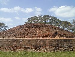
The original name of Bhattiprolu was Pratipalapura, a flourishing Buddhist town in the ancient Sala kingdom that predated Andhra Satavahanas. From available inscriptional evidence, King Kuberaka was ruling over Bhattiprolu around 230 BC. Bhattiprolu is well known for its Buddha stupa (Vikramarka kota dibba) built about 3rd-2nd century BC.
The stupa and the script
Three mounds were discovered in Bhattiprolu in 1870. In 1892 when excavations were undertaken by Alexander Rea, three inscribed stone relic caskets containing crystal caskets, relics of Buddha and jewels were found. The stupa was found to be 40 meters in diameter with an additional basement of 2.4 meters wide running all around. The most significant discovery is the crystal relic casket of sarira dhatu of the Buddha from the central mass of the stupas. The Mahachaitya (great stupa) remains of a large pillared hall, a large group of ruined votive stupas with several images of Buddha, a stone receptacle containing copper vessel, which in turn, contained two more, a silver casket and within it, a gold casket enclosing beads of bone and crystal were found.
One of the earliest evidence of Brahmi script in South India comes from Bhattiprolu. The script was written on an urn containing Buddha's relics. The script has been named the bhattiprolu alphabet. Historians surmise that this script gave rise to the Telugu Script and kannada script.
"A manual of Krishna District - in the madras presidency: 1883" mentions Public Works Department at that time having demolished beautiful marble pillars, central casket and used the remains in the sluice flowing 2 miles east of bhattiprolu
Geography
It is located at 16.1026°N 80.7807°E / 16.1026; 80.7807 and at an elevation of 6 m (20 ft).
Government and politics
Bhattiprolu gram panchayat is the local self-government of the village. The panchayat has a total of 16 wards and each ward is represented by an elected ward member. The ward members are headed by a sarpanch and the present sarpanch is Kambam Mariyamma.
Transport
The village has connectivity with National Highway 214A which passes through the village. APSRTC operates buses from Tenali and Repalle via Bhattiprolu. Bhattiprolu railway station is located on Tenali–Repalle branch line and administered under Guntur railway division of South Central Railway zone.