
Population 332 (2011 Census) Civil parish Berwick St John Local time Sunday 1:08 AM | OS grid reference ST947223 Unitary authority Dialling code 01747 | |
 | ||
Weather 5°C, Wind SW at 19 km/h, 86% Humidity | ||
stars appeal berwick st john country fayre 2012
Berwick St John is a village and civil parish in southwest Wiltshire, England, about 5 miles (8 km) east of Shaftesbury in Dorset.
Contents
- stars appeal berwick st john country fayre 2012
- Map of Berwick St John UK
- Geography
- Demography
- History
- Religious sites
- Amenities
- References
Map of Berwick St. John, UK
The parish includes the Ashcombe Park estate, part of the Ferne Park estate, and most of Rushmore Park (since 1939 the home of Sandroyd School).
Geography
The parish is at the head of the Ebble valley, in the Cranborne Chase Area of Outstanding Natural Beauty.
Winklebury Hill overlooks the village. In the extreme west of the parish, Win Green hill, at 277 metres (909 ft), is the highest point of Cranborne Chase. The southern part of the parish is forested and includes a golf course.
Demography
The 2011 Census misleadingly records the output area as the parish population as '438' in which figure is incorporated the civil parish together with that of Alvediston to the east for reasons of confidentiality of the other detailed figures. The county council have obtained and published key statistics for each parish showing that Berwick St John's population stood at 332 in that census. The combined area is 28.68 km² In 1861 residents numbered a maximal 499 but this had fallen to a low of 258 at the 1971 census.
History
The area has several prehistoric sites, including a Bronze Age settlement near Rushmore.
Part of Wilton Abbey's Chalke estate from the 10th century, the parish was established by the 13th century. Manors of the parish included Berwick St John, Rushmore, Bridmore, Upton Lucy and Ashcombe.
The Old Rectory is from the early 19th century.
In the 19th century Augustus Pitt Rivers inherited the Rushmore estate and excavated many nearby archaeological sites.
Religious sites
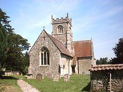
The Church of England parish church of St John the Baptist was built in the 14th century but heavily restored in 1861 under the direction of the Gothic revival architect Henry Woodyer. It has stained glass windows that have been attributed to Hardman & Co. The building is Grade II listed.
The tower has a ring of six bells. Robert I Wells of Aldbourne cast the second, third and tenor bells in 1767. Robert II Wells cast the fifth bell in 1788. John Warner & Sons of Cripplegate, London cast the treble and fourth bells in 1885.
St John's parish is a member of the Benefice of Chalke Valley.
Ebenezer Baptist Chapel was built in 1828 and closed in 1984. A Wesleyan Methodist chapel was built in 1875 and closed sometime before 1964.
Amenities
The village has a pub, the Talbot Inn, which dates from the mid-17th century.
There is no primary school. A school which was built in 1835 took children of all ages until 1935; it was closed in 1963.
Sandroyd School, at Rushmore House, is an independent school for children aged 3–13.