
Time zone +5 GMT Area code(s) +(993) 247 XX XXX Area 18.63 km² Local time Friday 7:18 PM | Postal code 745130 Elevation 205 m Urban area 9.342 km² Province Balkan Region | |
 | ||
Weather 13°C, Wind E at 37 km/h, 34% Humidity | ||
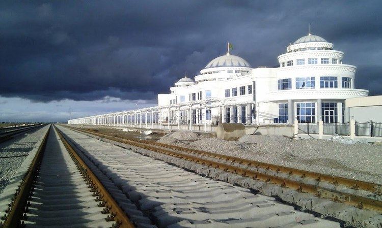
Perspectives of new railway uzen bereket gorgan
Bereket, formerly Gazandjyk or Kazandzhik (Russian: Казанджик or Газанджык), is a city in Balkan Province in western Turkmenistan. Bereket is the administrative centre of the Bereket District.
Contents
- Perspectives of new railway uzen bereket gorgan
- Map of Bereket Turkmenistan
- Etymology
- History
- Geography
- Demographics
- Economy
- Finance
- Communication
- City and national transportation
- Role in transnational transportation
- Education health culture
- Climate
- Sightseeing
- Bereket Railway Station
- References
Map of Bereket, Turkmenistan
The city is located in an oasis in the foothills of the Kopetdag Mountains and on the edge of the Karakum Desert.
Bereket is an important strategic railway intersection of the Trans-Caspian Railway (Caspian Sea-Turkmenistan-Uzbekistan-Kazakhstan) and North-South Transnational Railway (Russia-Kazakhstan-Turkmenistan-Iran-Persian Gulf.
The city has a large locomotive repair depot and a modern railway station.
The city is located approximately 260 km (162 mi) west of the Turkmen capital of Ashgabat and 340 km (211 mi) east of the Caspian Sea port of Turkmenbashi. The largest cities nearby are Balkanabat 120 km (75 mi) to the west, and Serdar 90 km (56 mi) to the east.
The estimated population of the city is 24,500 as of March 2015.
Etymology
The exact origin of the name is unknown. Gazanjyk is probably derived from a Turkic language word gazan or kazan (meaning a large cooking pot used throughout Central Asia, roughly equivalent to a cauldron, boiler) and -jyk a suffix to denote small in size. The name can be translated into English as small kazan or small cauldron. The present-day name of the city Bereket in the Turkmen language means abundance or prosperity. The word Bereket is borrowed from the Persian word Barakat (برکت) into Turkmen. Persian in turn has borrowed it from Arabic Barakah (برکة).
History
Since ancient times the area where city is now located was known as an important junction on the famous Silk Road that connected China with the Middle East and Europe.
Aleksey Kuropatkin, the Imperial Russian Army commander of the Turkestan Rifle Brigade, who made an 18-day march in 1880-1881 across 500 miles of Karakum desert writes in his memoirs "the 5th transition to Kazandjik - 64 miles. A waterless road. The soil is sandy, clayey, alkaline; there are sparse clumps of weeds and even sparser haloxylon trees four feet in height. This transition separates the Balkan mountains from Kyurendag. Kazandjik wells lie in the gorge of the Kyurendag mountains, along the stream of a small river. Water in the wells is fresh and of good quality."
After the conquest of the Transcaspian Oblast the Russian Empire started to build the Trans-Caspian railway including towns and settlements along the route. Kazandjik, as an urban city, was founded in 1895 to serve as an important junction on the railway.
In 1916–1942 Kazandjik and the area around the town was the scene of furious battles between Russian Imperial forces, and after 1918 Soviet Red Army, with local nationalist Muslims, during the Basmachi movement.
During Soviet period the 61631th army garrison had been built on the outskirts of the city. In 1988 it had stationed strong army units, the 231th tank regiment, the 160th motorized rifle regiment and the 405th artillery regiment.
The December 2000 Turkmenistan earthquake (7.0 on the moment magnitude scale) devastated the city center.
Geography
See satellite image of Bereket.
The city is located on the most western foothills of the Kopetdag mountains called Kyurendag on the edge of the Karakum deserts. The maximum height of the Kyurendag ridge is 968 m (3,176 ft). The vegetation of the ridge is quite poor and is represented primarily by species of desert flora, sagebrush, semi-desert and dry steppe and rocky outcrops. Soils - gray soils. One can occasionally find juniper trees, single or large groups of tamarisk and small shrubs. Wildlife in recent years has become greatly impoverished. Ungulates are few in number. Argali sheep are seen occasionally, as are bezoar goats and wild boars, gazelles. Predators includewolves, jackals, foxes, hyenas. Among birds klik are rarely seen and stone curlews and jacks very rarely. Reptile species are represented by the steppe tortoise, monitor lizard, boa, agam, etc.
The major source of water for irrigation is the Karakum Canal.
Demographics
The city is divided into several aul - neighborhoods. The majority of the inhabitants are Turkmen from the Yomud tribes, with a minority of Teke. Previously strong communities of Azeris, Armenians, Russians, Ukrainians and Persians are now reduced to several families. In the 1990s most of them migrated to larger cities for better economic opportunities. Many Russian families also emigrated to the Russian Federation.
Economy
The city is the semi-industrial and semi-agricultural centre of the Bereket District. It is an important railway and automobile junction, the city has a large railroad yard and locomotive repair depot, a brick production factory, Turkmen carpet weaving factory, wheat and cotton processing and storage facilities. Animal breeding (camels, cows, sheep) is another source of income.
In September 2014 a poultry complex with production capacity of 8 million eggs and 1000 tons of poultry meat a year was constructed.
Finance
The State Commercial Bank Dayhanbank has its branch office in Bereket.
Communication
The postal area code for the city is 745130. The city has a stable mobile coverage by two mobile communication operators, the state-owned Altyn Asyr and Russian-owned MTS Turkmenistan.
City and national transportation
The city has a small public transportation network. Several small buses run scheduled routes connecting the eastern and western parts of the city (some 5–6 km.)
Bereket is an important railway junction and station for commercial and freight transportation on the Turkmenistan national railway system.
Role in transnational transportation
Bereket city (Kazandzhik) is a strategically important railway crossing of the Trans-Caspian Railway (Caspian Sea, Turkmenistan, Uzbekistan and eastern Kazakhstan) and North-South Transnational Railway (Russia-Kazakhstan-Turkmenistan-Iran-Persian Gulf). The city has a large locomotive repair depot and a modern passenger railway station.
The Kazakhstan-Turkmenistan-Iran railway link is a part of the North–South Transport Corridor and is a 677 km (421 mi) long railway line connecting Kazakhstan and Turkmenistan with Iran and the Persian Gulf. It links Uzen in Kazakhstan with Bereket - Etrek in Turkmenistan and ends at Gorgan in Iran's Golestan province. In Iran, the railway will be linked to the national network making its way to the ports of the Persian Gulf. The project is estimated to cost $620m which is being jointly funded by the governments of Kazakhstan, Turkmenistan and Iran.
In May 2013, the 311 km (193 mi) Bereket – Uzen section of the North-South Transnational Railway was completed. In February 2014 256 km (159 mi) long section between Bereket and Etrek was completed. Currently railway stations along the new railway are being constructed such as Däneata, Dövletýar, Bugdaýly, Balguýi, Madaw, Akjadepe.
The Kazakhstan-Turkmenistan-Iran railway link will be officially inaugurated in October 2014.
The city is located on the M37 Highway (Turkmenistan section of the European route E60 which connects Brest, France to Irkeshtam, Kyrgyzstan on the border with People's Republic of China).
Education, health, culture
The city has three public schools, kindergartens, a small hospital, and medical emergency centre.
In 2012 several new buildings were constructed within the State Development Program including the mayor's office (hakimlik), two schools, a hotel, cultural center, a hospital and a knitting factory.
Until 2000, the city had a library, two open-air and one winter cinema. All are currently closed.
Climate
Bereket has a desert climate, with generally warm winters and very hot summers. Rainfall is generally light and erratic, and occurs mainly in the winter and autumn months. In summer, day temperatures may rise to 42-44 C', and during nights fall to 15-18 C'. The air flow is windy, chilly in winters and dusty in summers.
Sightseeing
In its storage area, the Bereket Depot museum, has a relic Russian made class T locomotive ТЭ-189 (built between 1857—1915).
FD class steam locomotives ФД20-2526, ФД20-2494 (ФД20-1441) (built between 1931-1942), and Russian class E locomotives Эр796-88, Эм734-66 (Эм733-96), Эу705-41, Эм725-30, Э-13 (built between 1912—1957).
There are also several ТЭ1 class locomotives, whose prototype was the famous US made ALCO RSD-1 locomotive.
Bereket Railway Station
Bereket Railway Station (Turkmen: Bereket demirýol menzili) is the main railway station in the city. It was built in 1885. The station is operated by the Türkmendemirýollary.