
Country United States County Logan Time zone Eastern (EST) (UTC-5) Elevation 379 m Population 13,193 (2013) | State Ohio Founded 1817 Area code(s) 937 Zip code 43311 Local time Thursday 9:14 AM | |
 | ||
Weather -1°C, Wind NW at 24 km/h, 70% Humidity | ||
The haunted orchard haunted hike bellefontaine ohio
Bellefontaine (/bɛlˈfaʊntᵻn/ bel-FOWN-tin) is a city in and the county seat of Logan County, Ohio, United States. The population was estimated at 13,322 in 2011. It is the center of the Bellefontaine Micropolitan Statistical Area, which includes all of Logan County, as defined by the United States Census Bureau in 2003. The highest point in Ohio, Campbell Hill, is within the city limits of Bellefontaine.
Contents
- The haunted orchard haunted hike bellefontaine ohio
- Map of Bellefontaine OH 43311 USA
- Old views of bellefontaine ohio
- History
- Blue Jackets Town
- Railroads
- Automotive transportation
- Campbell Hill
- Geography
- Climate
- Demographics
- 2010 census
- Micropolitan statistical area
- Government
- Sites of interest
- Logan County Historical Society
- Education
- Transportation
- Media
- Representation in other media
- Notable people
- References
Map of Bellefontaine, OH 43311, USA
Old views of bellefontaine ohio
History
The name Bellefontaine means "beautiful spring" in French, and is purported to refer to several springs in the area.
Blue Jacket's Town
Around 1777, the Shawnee war chief Blue Jacket (Weyapiersenwah) built a settlement here, known as Blue Jacket's Town. Blue Jacket and his band had previously occupied a village along the Scioto River, but the American Revolutionary War had reached the Ohio Country. Blue Jacket and other American Indians who took up arms against the American revolutionaries relocated in order to be closer to their British allies at Detroit.
After the United States gained independence, its forces continued warfare against former Indian allies of the British. Blue Jacket's Town was destroyed in Logan's Raid, conducted by Kentucky militia in 1786 at the outset of the Northwest Indian War. The expedition was led by Benjamin Logan, namesake of Logan County. Blue Jacket and his followers relocated further northwest to the Maumee River.
Beginning in the 1800s, American Revolutionary War veterans and others from Virginia and elsewhere began settling in the area of Blue Jacket's Town. Bellefontaine is on or near the edge of the Virginia Military District, where the cash-poor government granted tracts of land to veterans in payment for their services during the war. The Treaty of Greenville defined lands to be held by European Americans as separate from those to be held by natives but it was poorly administered in the area and whites frequently encroached on native lands.
Railroads
Bellefontaine was platted by European Americans in 1820 and incorporated by the legislature in 1835. In 1837, the Mad River & Lake Erie Railroad built the first railroad to Bellefontaine. This began its reputation as a railroading town. In the 1890s the Cleveland, Cincinnati, Chicago and St. Louis Railroad (also called the Big Four Railroad) built a main terminal in the city. This terminal boasted the largest roundhouse between New York and St. Louis.
Though railroading hit hard times and the industry went through radical restructuring in the late 20th century, and the Big Four terminal ceased operations in 1983, Bellefontaine remains a landmark on America's railways. The city is at the junction of CSX lines going to Cleveland, Indianapolis, and Dayton.
Automotive transportation
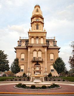
In 1891, Bellefontaine became the location of the first concrete street in America. George Bartholomew invented a process for paving using Portland cement, which until then had been used in stone construction. A small section of Main Street, on the west side of the Logan County Courthouse, was the first to be paved using that process. When that proved successful, Court Avenue, which runs along the south side of the courthouse, was paved with concrete. While Main Street is now paved with asphalt, Court Avenue has retained its original concrete pavement for more than 100 years. At its centennial, the street was closed to traffic and a statue of Bartholomew placed at its Main Street end; it became a pedestrian way. Since then one lane has been reopened for eastbound traffic.
In 1979, Honda began manufacturing motorcycles in the Columbus suburb of Marysville, Ohio. Since that time, Honda's operations in the Bellefontaine area have greatly expanded. Bellefontaine is a central location among Honda operations in Marysville, East Liberty, Russells Point, Anna, and Troy, Ohio. Honda is Bellefontaine's largest employer in the early 21st century.
U.S. Route 68 intersects with State Routes 47 and 540 in Bellefontaine. U.S. Route 33, a freeway that has interchanges with US 68 and SR 540, skirts the northern edge of the city.
Campbell Hill
To European settlers, Campbell Hill was first known as Hogue's Hill, perhaps a misspelling of Solomon Rogue's surname, the person who first deeded the land in 1830. In 1898, the land was sold to Charles D. Campbell, in whose name Campbell Hill is now known. Campbell sold the hill and surrounding land to August Wagner, who was the original brewer of Augustiner and Gambrinus beers. (These brands are now the trademarks of the Gambrinus Company of San Antonio, Texas, though the company has stopped production of these beers.)
In 1950, the family of August Wagner deeded Campbell Hill and the surrounding 57.5 acres to the U.S. government. The government stationed the 664th Aircraft Control and Warning Squadron on the hill in 1951. This military unit was responsible for monitoring for possible aerospace attacks from the Soviet Union during the Cold War. The 664th AC&WS and similar military units were eventually superseded by the North American Aerospace Defense Command (or NORAD). The base in Bellefontaine was closed in 1969.
The Ohio Hi-Point Vocational-Technical District opened a school atop the hill in 1974. The school is now known as the Ohio Hi-Point Career Center.
Geography
Bellefontaine is located at 40°21′39″N 83°45′29″W (40.360878, -83.758126). According to the 2010 census, the city has a total area of 10.04 square miles (26.0 km2), all land.
Climate
The city of Bellefontaine is at the convergence of the humid subtropical (Köppen Cfa) and humid continental (Köppen Dfa) climate zones according to the Köppen climate map. The region is characterized by four distinct seasons. Winters are cool to cold with mild periods, and summers are generally hot and muggy, with significant precipitation year round. The city is too far south to experience lake effect snow from the Great Lakes region, however it does experience more snow than surrounding areas due to the city's elevation. Traditionally, Bellefontaine's elevation excludes it from tornados and floods that affect the majority of the Miami Valley.
Demographics
As of the census of 2000, there were 13,069 people, 5,319 households, and 3,436 families residing in the city. The population density was 1,491.3 inhabitants per square mile (575.8/km2). There were 5,722 housing units at an average density of 652.9 per square mile (252.1/km2). The racial makeup of the city was 90.82% White, 5.13% African American, 0.15% Native American, 0.93% Asian, 0.04% Pacific Islander, 0.53% from other races, and 2.40% from two or more races. Hispanic or Latino of any race were 1.12% of the population.
There were 5,319 households of which 34.1% had children under the age of 18 living with them, 45.7% were married couples living together, 14.4% had a female householder with no husband present, and 35.4% were non-families. 30.5% of all households were made up of individuals and 11.9% had someone living alone who was 65 years of age or older. The average household size was 2.43 and the average family size was 3.01.
In the city the population was spread out with 28.1% under the age of 18, 10.0% from 18 to 24, 29.1% from 25 to 44, 19.9% from 45 to 64, and 12.9% who were 65 years of age or older. The median age was 33 years. For every 100 females there were 90.9 males. For every 100 females age 18 and over, there were 86.4 males.
The median income for a household in the city was $37,189, and the median income for a family was $43,778. The per capita income for the city was $20,917. About 19.9% of families and 23.6% of the population were below the poverty line, including 38.9% of those under the age of 18 and 10.9% of those ages 65 and older.
2010 census
As of the census of 2010, there were 13,370 people, 5,415 households, and 3,420 families residing in the city. The population density was 1,331.7 inhabitants per square mile (514.2/km2). There were 6,115 housing units at an average density of 609.1 per square mile (235.2/km2). The racial makeup of the city was 90.1% White, 4.3% African American, 0.2% Native American, 1.2% Asian, 0.5% from other races, and 3.7% from two or more races. Hispanic or Latino of any race were 1.9% of the population.
There were 5,415 households of which 35.2% had children under the age of 18 living with them, 41.1% were married couples living together, 15.9% had a female householder with no husband present, 6.1% had a male householder with no wife present, and 36.8% were non-families. 30.6% of all households were made up of individuals and 12.1% had someone living alone who was 65 years of age or older. The average household size was 2.44 and the average family size was 3.01.
The median age in the city was 34.8 years. 27.1% of residents were under the age of 18; 9.1% were between the ages of 18 and 24; 26.3% were from 25 to 44; 24.7% were from 45 to 64; and 12.8% were 65 years of age or older. The gender makeup of the city was 48.4% male and 51.6% female.
Micropolitan statistical area
Bellefontaine is the center of the Bellefontaine Micropolitan Statistical Area, as defined by the U.S. Census Bureau. This micropolis consists solely of Logan County, Ohio. The 2000 census found 46,005 people in the micropolis, making it the 260th most populous such area in the United States. Among all U.S. statistical areas (CBSAs), the Bellefontaine micropolis ranks 622nd. In Ohio, the Bellefontaine micropolis is the 37th most populous CBSA, and the 21st most populous micropolitan statistical area.
By comparison, the least populous metropolitan area in the United States, Carson City, Nevada, has 52,457 residents. The least populous metropolitan area in Ohio is Sandusky, with 79,555 residents. The Bellefontaine micropolis is not as populous as these, but does have a greater population than some micropolitan statistical areas traditionally considered to be small regional cities. (Examples: El Dorado, Arkansas; Clovis, New Mexico; and Red Wing, Minnesota.)
Though official definitions of micropolitan statistical areas did not exist until 2003, the area now constituting the Bellefontaine micropolis grew in population by 8.7 percent between 1990 and 2000.
Government
Bellefontaine has an elected mayor and city council style of government.
Bellefontaine City Council Members serve 4 year terms. The city is has 4 wards and 3 At-Large seats.
Sites of interest
Logan County Historical Society
The Logan County Historical Society and museum was first housed in the McBeth School, built in 1919 as the last of the four elementary schools to be built in Bellefontaine at the turn of the century. The building was sold at public auction in 1957 to the Church of God. In 1971 McBeth School was purchased by the Logan County Historical Society for use as the Logan County Historical Museum. The historical society eventually grew out of the 3-story building and moved to its current home closer to Downtown. McBeth School has been adapted for use as an apartment building.
Today the museum includes the Orr mansion, former home of the local Orr family; as well as an extension to the mansion that includes history exhibits from around the county. The Mansion portion of the building has been completely restored by the historical society. Day-to-day operations in the museum and The Logan County Historical Society are supported by a Logan County tax levy and donations received from visitors to the museum. Donations also can be contributed to the society to be used in historical displays. Recent donations in the 21st century include the 1950s era "house call" bag from local doctor George E. Nixon.
Education
The Bellefontaine City Schools operate one elementary school,one intermediate school, one middle school, and one high school in the area. These schools have a combined enrollment of 2,840. In addition, the Ohio Hi-Point Career Center, located atop Campbell Hill, offers both secondary and post-secondary education. Enrolled at Ohio Hi-Point are 505 students. The neighboring Benjamin Logan Local School District campus also has a Bellefontaine address.
Several colleges and universities operate satellite campuses in the Bellefontaine area. These include:
Transportation
The Bellefontaine Regional Airport is located about 5 miles from the downtown business district. The airport replaced the Bellefontaine Municipal Airport in 2002 and is one of 2 new airports opened to the public in Ohio in the past 30 years.
Media
The city is served by both print publishing and radio broadcasting.
The Bellefontaine Examiner is the daily local newspaper. It is the latest in a series of newspapers which have been published in Bellefontaine since 1831. It has a current daily circulation of approximately 9500 copies.
Operating currently are WPKO, an FM radio station, and its sister station WBLL, an AM radio station. These stations are owned and operated by V-Tech Communications.