
Length 470 km Country United States of America | ||
 | ||
Belle fourche river
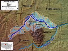
The Belle Fourche River (pronounced bel FOOSH; Lakota: 'Šahíyela Wakpá') is a tributary of the Cheyenne River, approximately 290 miles (470 km) long, in the U.S. states of Wyoming and South Dakota. It is part of the Mississippi River watershed via the Cheyenne and Missouri rivers. In the latter part of the 19th century, the Belle Fourche River was known as the North Fork of the Cheyenne River. Belle Fourche is a name derived from French meaning "beautiful fork".
Contents
- Belle fourche river
- Map of Belle Fourche River Dakota Township SD USA
- Dakota sportsmen tv sunset over the belle fourche river
- References
Map of Belle Fourche River, Dakota Township, SD, USA
It rises in northeastern Wyoming, in southern Campbell County, approximately 15 miles (24 km) north of Wright. It flows northeast around the north side of the Bear Lodge Mountains, past Moorcroft and Devils Tower. Near the state line with Montana, it turns abruptly southeast and flows in western South Dakota, past Belle Fourche and around the north side of the Black Hills. In southern Meade County near Hereford, it turns ENE and joins the Cheyenne approximately 50 miles (80 km) ENE of Rapid City.
The point at which the river flows out of Wyoming and into South Dakota is the lowest elevation point in the state of Wyoming at 3,099 feet (945 m). This is the second-highest low point of any U.S. state.
The river provides significant recreation and irrigation for agriculture in western South Dakota. The total irrigation area of the river in South Dakota is approximately 57,000 acres (230 km2).