
Palestine grid 160/143 Name meaning "Upper House of Ur" | ||
 | ||
Weather 10°C, Wind S at 10 km/h, 96% Humidity | ||
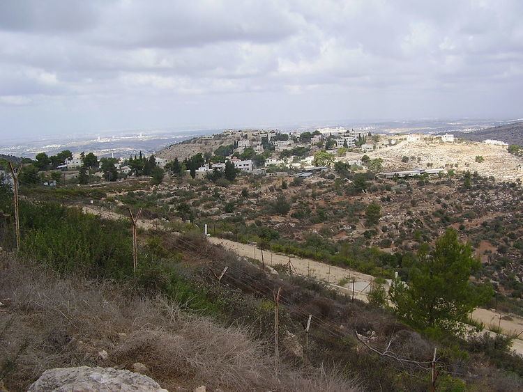
Beit Ur al-Fauqa (Arabic: بيت عور الفوقا) is a Palestinian village located in the Ramallah and al-Bireh Governorate in the northern West Bank, 14 kilometers (8.7 mi) east of Ramallah and 3 kilometers (1.9 mi) southeast of Beit Ur al-Tahta. According to the Palestinian Central Bureau of Statistics, it had a population of 864 in the 2007 census.
Contents
Map of Bayt Ghur al-Foqa
History
Beit Ur al-Fauqa (meaning "Upper House of Straw") preserves part of the original Canaanite name for the village, and has been identified as the sites of Upper Bethoron. Archaeological finds indicate that Lower Bethoron (Beit Ur al-Tahta) was established before Upper Bethoron; potsherds found in Beit Ur al-Fauqa date from the Iron Age onward, while potsherds from the lower town date from the Late Bronze Age. A large birkeh (pond) north-east in the village is cut in rock.
The Hasmoneans twice blocked the way of Hellenistic forces marching toward Jerusalem in Upper Bethoron. In the third attempt, Bacchides succeeded in subduing the Hasmoneans and fortified this strategic pass. It was in the ravines near Bethoron that the 12th Roman Legion under Cestius Gallus was destroyed in 66 CE at the start of the Great Jewish Revolt. After the subjugation of the Jewish Revolt in 70 CE, the Romans built a fortress in the town to guard the road to Jerusalem. During the later Roman period and under the Byzantines, Beit Ur al-Fauqa lost its importance, becoming a small village by the 5th century CE.
The village has been identified with the Bethoron Superior or Vetus Betor in the Crusader era. Melisende, Queen of Jerusalem gave it as a fief to Mar Saba. In 1165/64 CE, it was sold to the canons of the Holy Sepulchre. The remains of a tower, Al-Burj, in the village is dated to this era.
An Arabic inscription with a verse from the Qur'an was found on a ruined stone structure in Beit Ur al-Fauqa and is attributed by Moshe Sharon to the Ayyubid period of rule in Palestine.
Ottoman era
Beit Ur al-Fauqa, like the rest of Palestine, was incorporated into the Ottoman Empire in 1517, and in the census of 1596, the village appeared in the tax registers as being in the Nahiya of Quds of the Liwa of Quds. It had a population of 5 Muslim households and paid taxes on wheat, barley, olives, goats and/or beehives.
The French explorer Victor Guérin visited the village in 1863, and he described it as having about 150 inhabitants, and surrounded by gardens of olive trees. He also noted the remains of a small castle. An official Ottoman village list from about 1870 showed that Bet Ur el-Foqa had 53 houses and a population of 159, though it only counted the men. In 1883, the Palestine Exploration Fund's Survey of Western Palestine described Beit Ur Al Foka as "A small village built of stone at the end of a spur on a knoll. The ground falls very steeply to the west. The water supply is artificial, and on the north and south are deep valleys. The west view is very extensive, including the sea, the plains of Lydda and Ramleh, and part of the valley of Ajalon."
British Mandate era
In a census conducted in 1922 by the British Mandate authorities, Beit 'Ur al-Fuqa had a population of 147, all Muslim. By the time of the 1931 census, Beit 'Ur al-Fauqa had 47 occupied houses and a population of 173, still all Muslim.
In 1945 the population was 210, all Arabs, while the total land area was 3,762 dunams, according to an official land and population survey. Of this, 989 were allocated for plantations and irrigable land, 1,277 for cereals, while 26 dunams were classified as built-up areas.
1948-1967
In the wake of the 1948 Arab–Israeli War, and after the 1949 Armistice Agreements, Beit Ur al-Fauqa came under Jordanian rule.
post-1967
After Six-Day War in 1967, Beit Ur al-Fauqa has been under Israeli occupation. After a settlement road denied them land access to their school, the children of the village now commute to the local al-Tira Beit Ur al-Fuqa high school, which is surrounded by the Israeli separation wall on three sides, through sewage channels.
Geography
The villages of Beit Ur crown two hilltops, less than 2 miles (3.2 km) apart (with Beit Ur al-Fauqa some 245 meters (804 ft) higher than Beit Ur al-Tahta) along Route 443, the Biblical way of Bethoron. For many centuries, the villages occupying their sites dominated one of the most historic roads in history. The ridge way of Bethoron climbs from the plain of Aijalon (the modern Yalo) to Beit Ur al-Tahta at 370 meters (1,210 ft); it then carries along the ridge, with valleys lying either side, north and south, before reaching Beit Ur al Fauqa at 616 meters (2,021 ft). The ridge continues for another 8 kilometers (5.0 mi) arriving at the plateau to the north of al-Jib (Gibeon).